La Malhoure
La Malhoure
Lanvelor | |
|---|---|
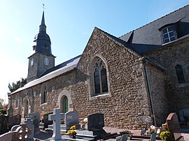 The church of Saint-Event | |
 Coat of arms | |
show Location of La Malhoure | |
 La Malhoure | |
| Coordinates: 48°23′52″N 2°29′36″W / 48.3978°N 2.4933°WCoordinates: 48°23′52″N 2°29′36″W / 48.3978°N 2.4933°W | |
| Country | France |
| Region | Brittany |
| Department | Côtes-d'Armor |
| Arrondissement | Saint-Brieuc |
| Canton | Lamballe |
| Intercommunality | Lamballe Terre et Mer |
| Government | |
| • Mayor (2014–2020) | Daniel Baron |
| Area 1 | 5.02 km2 (1.94 sq mi) |
| Population (Jan. 2018)[1] | 596 |
| • Density | 120/km2 (310/sq mi) |
| Time zone | UTC+01:00 (CET) |
| • Summer (DST) | UTC+02:00 (CEST) |
| INSEE/Postal code | 22140 /22640 |
| Elevation | 77–141 m (253–463 ft) |
| 1 French Land Register data, which excludes lakes, ponds, glaciers > 1 km2 (0.386 sq mi or 247 acres) and river estuaries. | |


La Malhoure (Breton: Lanvelor) is a commune in the Côtes-d'Armor department of Brittany in northwestern France.
Population[]
| Year | Pop. | ±% |
|---|---|---|
| 1962 | 229 | — |
| 1968 | 238 | +3.9% |
| 1975 | 229 | −3.8% |
| 1982 | 237 | +3.5% |
| 1990 | 266 | +12.2% |
| 1999 | 348 | +30.8% |
| 2008 | 458 | +31.6% |
Inhabitants of La Malhoure are called malhourins or malhourains in French.
See also[]
References[]
- ^ "Populations légales 2018". INSEE. 28 December 2020.
| Wikimedia Commons has media related to La Malhoure. |
This Côtes-d'Armor geographical article is a stub. You can help Wikipedia by . |
Categories:
- Communes of Côtes-d'Armor
- Côtes-d'Armor geography stubs