Tréméven, Côtes-d'Armor
Tréméven
Tremeven-Goueloù | |
|---|---|
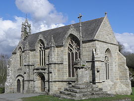 The chapel of Saint-Jacques, in Tréméven | |
show Location of Tréméven | |
 Tréméven | |
| Coordinates: 48°40′25″N 3°01′39″W / 48.6736°N 3.0275°WCoordinates: 48°40′25″N 3°01′39″W / 48.6736°N 3.0275°W | |
| Country | France |
| Region | Brittany |
| Department | Côtes-d'Armor |
| Arrondissement | Guingamp |
| Canton | Plouha |
| Intercommunality | Leff Armor Communauté |
| Government | |
| • Mayor (2014–2020) | Chantal Delugin |
| Area 1 | 5.12 km2 (1.98 sq mi) |
| Population (Jan. 2018)[1] | 345 |
| • Density | 67/km2 (170/sq mi) |
| Time zone | UTC+01:00 (CET) |
| • Summer (DST) | UTC+02:00 (CEST) |
| INSEE/Postal code | 22370 /22290 |
| Elevation | 20–87 m (66–285 ft) |
| 1 French Land Register data, which excludes lakes, ponds, glaciers > 1 km2 (0.386 sq mi or 247 acres) and river estuaries. | |


Tréméven (Breton: Tremeven-Goueloù) is a commune in the Côtes-d'Armor department of Brittany in northwestern France.
Population[]
Inhabitants of Tréméven are called Trémévénais in French.
| Year | Pop. | ±% |
|---|---|---|
| 1962 | 280 | — |
| 1968 | 311 | +11.1% |
| 1975 | 290 | −6.8% |
| 1982 | 247 | −14.8% |
| 1990 | 286 | +15.8% |
| 1999 | 277 | −3.1% |
| 2008 | 341 | +23.1% |
See also[]
References[]
- ^ "Populations légales 2018". INSEE. 28 December 2020.
External links[]
| Wikimedia Commons has media related to Tréméven (Côtes-d'Armor). |
- Official website (in French)
- Base Mérimée: Search for heritage in the commune, Ministère français de la Culture. (in French)
| show Authority control |
|---|
This Côtes-d'Armor geographical article is a stub. You can help Wikipedia by . |
Categories:
- Communes of Côtes-d'Armor
- Côtes-d'Armor geography stubs