Trégomeur
Trégomeur
Tregonveur | |
|---|---|
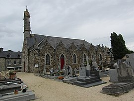 The church of Saint-Gildas, in Trégomeur | |
 Coat of arms | |
show Location of Trégomeur | |
 Trégomeur | |
| Coordinates: 48°33′59″N 2°52′50″W / 48.5664°N 2.8806°WCoordinates: 48°33′59″N 2°52′50″W / 48.5664°N 2.8806°W | |
| Country | France |
| Region | Brittany |
| Department | Côtes-d'Armor |
| Arrondissement | Guingamp |
| Canton | Plélo |
| Government | |
| • Mayor (2020–2026) | Denis Manac'h[1] |
| Area 1 | 10.37 km2 (4.00 sq mi) |
| Population (Jan. 2018)[2] | 936 |
| • Density | 90/km2 (230/sq mi) |
| Time zone | UTC+01:00 (CET) |
| • Summer (DST) | UTC+02:00 (CEST) |
| INSEE/Postal code | 22356 /22590 |
| Elevation | 20–123 m (66–404 ft) |
| 1 French Land Register data, which excludes lakes, ponds, glaciers > 1 km2 (0.386 sq mi or 247 acres) and river estuaries. | |


Trégomeur (Breton: Tregonveur) is a commune in the Côtes-d'Armor department of Brittany in northwestern France.
Population[]
| Year | Pop. | ±% |
|---|---|---|
| 1962 | 559 | — |
| 1968 | 595 | +6.4% |
| 1975 | 610 | +2.5% |
| 1982 | 689 | +13.0% |
| 1990 | 682 | −1.0% |
| 1999 | 729 | +6.9% |
| 2008 | 896 | +22.9% |
Inhabitants of Trégomeur are called trégomeurois in French.
See also[]
References[]
- ^ "Répertoire national des élus: les maires". data.gouv.fr, Plateforme ouverte des données publiques françaises (in French). 2 December 2020.
- ^ "Populations légales 2018". INSEE. 28 December 2020.
| Wikimedia Commons has media related to Trégomeur. |
This Côtes-d'Armor geographical article is a stub. You can help Wikipedia by . |
Categories:
- Communes of Côtes-d'Armor
- Côtes-d'Armor geography stubs