Tréogan
Tréogan
Treogan | |
|---|---|
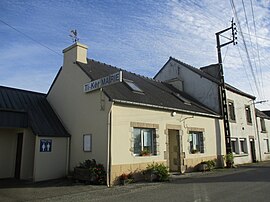 The town hall of Tréogan | |
 Coat of arms | |
show Location of Tréogan | |
 Tréogan | |
| Coordinates: 48°11′24″N 3°31′07″W / 48.19°N 3.5186°WCoordinates: 48°11′24″N 3°31′07″W / 48.19°N 3.5186°W | |
| Country | France |
| Region | Brittany |
| Department | Côtes-d'Armor |
| Arrondissement | Guingamp |
| Canton | Rostrenen |
| Intercommunality | Poher Communauté |
| Government | |
| • Mayor (2020–2026) | Honoré Lescoat[1] |
| Area 1 | 7.10 km2 (2.74 sq mi) |
| Population (Jan. 2018)[2] | 101 |
| • Density | 14/km2 (37/sq mi) |
| Time zone | UTC+01:00 (CET) |
| • Summer (DST) | UTC+02:00 (CEST) |
| INSEE/Postal code | 22373 /22340 |
| Elevation | 135–293 m (443–961 ft) |
| 1 French Land Register data, which excludes lakes, ponds, glaciers > 1 km2 (0.386 sq mi or 247 acres) and river estuaries. | |


Tréogan (Breton: Treogan) is a commune in the Côtes-d'Armor department of Brittany in northwestern France.
Population[]
Inhabitants of Tréogan are called tréoganais in French.
|
|
See also[]
References[]
- ^ "Répertoire national des élus: les maires". data.gouv.fr, Plateforme ouverte des données publiques françaises (in French). 2 December 2020.
- ^ "Populations légales 2018". INSEE. 28 December 2020.
External links[]
| Wikimedia Commons has media related to Tréogan. |
- Base Mérimée: Search for heritage in the commune, Ministère français de la Culture. (in French)
This Côtes-d'Armor geographical article is a stub. You can help Wikipedia by . |
Categories:
- Communes of Côtes-d'Armor
- Côtes-d'Armor geography stubs