Trélévern
Trélévern
Trelêvern | |
|---|---|
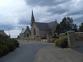 The church of Saint-Léonore and Sainte-Anne | |
 Coat of arms | |
show Location of Trélévern | |
 Trélévern | |
| Coordinates: 48°48′33″N 3°22′14″W / 48.8092°N 3.3706°WCoordinates: 48°48′33″N 3°22′14″W / 48.8092°N 3.3706°W | |
| Country | France |
| Region | Brittany |
| Department | Côtes-d'Armor |
| Arrondissement | Lannion |
| Canton | Perros-Guirec |
| Intercommunality | Lannion-Trégor Communauté |
| Government | |
| • Mayor (2020–2026) | Yannick Quéguiner |
| Area 1 | 6.94 km2 (2.68 sq mi) |
| Population (Jan. 2018)[1] | 1,244 |
| • Density | 180/km2 (460/sq mi) |
| Time zone | UTC+01:00 (CET) |
| • Summer (DST) | UTC+02:00 (CEST) |
| INSEE/Postal code | 22363 /22660 |
| Elevation | 0–92 m (0–302 ft) |
| 1 French Land Register data, which excludes lakes, ponds, glaciers > 1 km2 (0.386 sq mi or 247 acres) and river estuaries. | |


Trélévern (French pronunciation: [tʁelevɛʁn]; Breton: Trelêvern) is a commune in the Côtes-d'Armor department of Brittany in northwestern France located at the intersection of the touristic Côte de granit rose (pink granite Coast) and the quieter and wilder Côte des ajoncs d'or (golden gorses Coast).[2]
Population[]
Inhabitants of Trélévern are called trélévernais in French.
See also[]
References[]
External links[]
| Wikimedia Commons has media related to Trélévern. |
- Official website (in French)
This Côtes-d'Armor geographical article is a stub. You can help Wikipedia by . |
Categories:
- Communes of Côtes-d'Armor
- Côtes-d'Armor geography stubs