Moustéru
Moustéru
Mousteruz | |
|---|---|
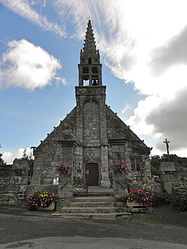 The church of Notre-Dame, in Moustéru | |
show Location of Moustéru | |
 Moustéru | |
| Coordinates: 48°31′05″N 3°14′16″W / 48.5181°N 3.2378°WCoordinates: 48°31′05″N 3°14′16″W / 48.5181°N 3.2378°W | |
| Country | France |
| Region | Brittany |
| Department | Côtes-d'Armor |
| Arrondissement | Guingamp |
| Canton | Callac |
| Intercommunality | Guingamp-Paimpol Agglomération |
| Government | |
| • Mayor (2014–2020) | Gérard Hervé |
| Area 1 | 14.28 km2 (5.51 sq mi) |
| Population (Jan. 2018)[1] | 650 |
| • Density | 46/km2 (120/sq mi) |
| Time zone | UTC+01:00 (CET) |
| • Summer (DST) | UTC+02:00 (CEST) |
| INSEE/Postal code | 22156 /22200 |
| Elevation | 110–295 m (361–968 ft) |
| 1 French Land Register data, which excludes lakes, ponds, glaciers > 1 km2 (0.386 sq mi or 247 acres) and river estuaries. | |


Moustéru (Breton: Mousteruz) is a commune in the Côtes-d'Armor department of Brittany in northwestern France.
Population[]
|
|
Inhabitants of Moustéru are called moustérusiens in French.
See also[]
References[]
- ^ "Populations légales 2018". INSEE. 28 December 2020.
External links[]
| Wikimedia Commons has media related to Moustéru. |
- Base Mérimée: Search for heritage in the commune, Ministère français de la Culture. (in French)
This Côtes-d'Armor geographical article is a stub. You can help Wikipedia by . |
Categories:
- Communes of Côtes-d'Armor
- Côtes-d'Armor geography stubs