Plourac'h
Plourac'h
Plourac'h | |
|---|---|
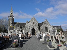 The church of Notre-Dame, in Plourac'h | |
show Location of Plourac'h | |
 Plourac'h | |
| Coordinates: 48°25′01″N 3°32′45″W / 48.4169°N 3.5458°WCoordinates: 48°25′01″N 3°32′45″W / 48.4169°N 3.5458°W | |
| Country | France |
| Region | Brittany |
| Department | Côtes-d'Armor |
| Arrondissement | Guingamp |
| Canton | Callac |
| Government | |
| • Mayor (2020–2026) | Yannick Larvor[1] |
| Area 1 | 32.15 km2 (12.41 sq mi) |
| Population (Jan. 2018)[2] | 317 |
| • Density | 9.9/km2 (26/sq mi) |
| Time zone | UTC+01:00 (CET) |
| • Summer (DST) | UTC+02:00 (CEST) |
| INSEE/Postal code | 22231 /22160 |
| Elevation | 125–284 m (410–932 ft) |
| 1 French Land Register data, which excludes lakes, ponds, glaciers > 1 km2 (0.386 sq mi or 247 acres) and river estuaries. | |


Plourac'h (Breton: Plourac'h) is a commune in the Côtes-d'Armor department of Brittany in northwestern France.
Population[]
|
|
Inhabitants of Plourac'h are called plouracois in French.
See also[]
- Communes of the Côtes-d'Armor department
- List of works of the two Folgoët ateliers
- Listing of the works of the Maître de Laz
References[]
- ^ "Répertoire national des élus: les maires". data.gouv.fr, Plateforme ouverte des données publiques françaises (in French). 2 December 2020.
- ^ "Populations légales 2018". INSEE. 28 December 2020.
External links[]
| Wikimedia Commons has media related to Plourac'h. |
- Official website (in French)
- Base Mérimée: Search for heritage in the commune, Ministère français de la Culture. (in French)
| show Authority control |
|---|
This Côtes-d'Armor geographical article is a stub. You can help Wikipedia by . |
Categories:
- Communes of Côtes-d'Armor
- Côtes-d'Armor geography stubs