Trébédan
Trébédan
Trebêran | |
|---|---|
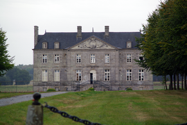 Chateau of Chalonge | |
 Coat of arms | |
show Location of Trébédan | |
 Trébédan | |
| Coordinates: 48°24′02″N 2°10′12″W / 48.4006°N 2.17°WCoordinates: 48°24′02″N 2°10′12″W / 48.4006°N 2.17°W | |
| Country | France |
| Region | Brittany |
| Department | Côtes-d'Armor |
| Arrondissement | Dinan |
| Canton | Plancoët |
| Intercommunality | Dinan Agglomération |
| Government | |
| • Mayor (2020–2026) | Didier Ibagne[1] |
| Area 1 | 10.97 km2 (4.24 sq mi) |
| Population (Jan. 2018)[2] | 426 |
| • Density | 39/km2 (100/sq mi) |
| Time zone | UTC+01:00 (CET) |
| • Summer (DST) | UTC+02:00 (CEST) |
| INSEE/Postal code | 22342 /22980 |
| Elevation | 84–115 m (276–377 ft) |
| 1 French Land Register data, which excludes lakes, ponds, glaciers > 1 km2 (0.386 sq mi or 247 acres) and river estuaries. | |


Trébédan (Breton: Trebêran) is a commune in the Côtes-d'Armor department of Brittany in northwestern France.
Population[]
| Year | Pop. | ±% |
|---|---|---|
| 1962 | 346 | — |
| 1968 | 365 | +5.5% |
| 1975 | 341 | −6.6% |
| 1982 | 431 | +26.4% |
| 1990 | 391 | −9.3% |
| 1999 | 384 | −1.8% |
| 2008 | 373 | −2.9% |
Inhabitants of Trébédan are called trébédannais in French.
See also[]
References[]
- ^ "Répertoire national des élus: les maires". data.gouv.fr, Plateforme ouverte des données publiques françaises (in French). 2 December 2020.
- ^ "Populations légales 2018". INSEE. 28 December 2020.
External links[]
| Wikimedia Commons has media related to Trébédan. |
- Base Mérimée: Search for heritage in the commune, Ministère français de la Culture. (in French)
This Côtes-d'Armor geographical article is a stub. You can help Wikipedia by . |
Categories:
- Communes of Côtes-d'Armor
- Côtes-d'Armor geography stubs