Othe
Othe | |
|---|---|
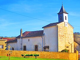 The church in Othe | |
 Coat of arms | |
show Location of Othe | |
 Othe | |
| Coordinates: 49°29′47″N 5°26′37″E / 49.4964°N 5.4436°ECoordinates: 49°29′47″N 5°26′37″E / 49.4964°N 5.4436°E | |
| Country | France |
| Region | Grand Est |
| Department | Meurthe-et-Moselle |
| Arrondissement | Briey |
| Canton | Mont-Saint-Martin |
| Government | |
| • Mayor (2020–2026) | Bernadette Delattre[1] |
| Area 1 | 2.97 km2 (1.15 sq mi) |
| Population (Jan. 2018)[2] | 34 |
| • Density | 11/km2 (30/sq mi) |
| Time zone | UTC+01:00 (CET) |
| • Summer (DST) | UTC+02:00 (CEST) |
| INSEE/Postal code | 54412 /54260 |
| Elevation | 188–310 m (617–1,017 ft) (avg. 200 m or 660 ft) |
| 1 French Land Register data, which excludes lakes, ponds, glaciers > 1 km2 (0.386 sq mi or 247 acres) and river estuaries. | |


Othe is a commune in the Meurthe-et-Moselle department in north-eastern France. It is an exclave of the Meurthe-et-Moselle department, surrounded by the Meuse department.
Geography[]
The village lies on the right bank of the Othain, which flows northwestward through the commune.
See also[]
References[]
- ^ "Répertoire national des élus: les maires". data.gouv.fr, Plateforme ouverte des données publiques françaises (in French). 2 December 2020.
- ^ "Populations légales 2018". INSEE. 28 December 2020.
| Wikimedia Commons has media related to Othe. |
This Meurthe-et-Moselle geographical article is a stub. You can help Wikipedia by . |
Categories:
- Communes of Meurthe-et-Moselle
- Meurthe-et-Moselle geography stubs