Saint-Ferme
Saint-Ferme | |
|---|---|
 The town hall in Saint-Ferme | |
show Location of Saint-Ferme | |
 Saint-Ferme | |
| Coordinates: 44°41′41″N 0°03′31″E / 44.6947°N 0.0586°ECoordinates: 44°41′41″N 0°03′31″E / 44.6947°N 0.0586°E | |
| Country | France |
| Region | Nouvelle-Aquitaine |
| Department | Gironde |
| Arrondissement | Langon |
| Canton | Le Réolais et Les Bastides |
| Government | |
| • Mayor (2008–2014) | Bernard Rebillou |
| Area 1 | 20.09 km2 (7.76 sq mi) |
| Population (Jan. 2018)[1] | 344 |
| • Density | 17/km2 (44/sq mi) |
| Time zone | UTC+01:00 (CET) |
| • Summer (DST) | UTC+02:00 (CEST) |
| INSEE/Postal code | 33400 /33580 |
| Elevation | 30–126 m (98–413 ft) |
| 1 French Land Register data, which excludes lakes, ponds, glaciers > 1 km2 (0.386 sq mi or 247 acres) and river estuaries. | |


Saint-Ferme is a commune in the Gironde department in Nouvelle-Aquitaine in southwestern France.
Population[]
| Year | Pop. | ±% |
|---|---|---|
| 1962 | 548 | — |
| 1968 | 505 | −7.8% |
| 1975 | 404 | −20.0% |
| 1982 | 382 | −5.4% |
| 1990 | 369 | −3.4% |
| 1999 | 338 | −8.4% |
| 2008 | 361 | +6.8% |
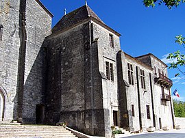
Abbey Church of Saint-Ferme[]
The church features a 12th-century nave and remarkably well-preserved Romanesque capitals, with themes such as Daniel in the Lions' Den and the Fall of Adam and Eve.
See also[]
References[]
- ^ "Populations légales 2018". INSEE. 28 December 2020.
| Wikimedia Commons has media related to Saint-Ferme. |
| show Authority control |
|---|
This Gironde geographical article is a stub. You can help Wikipedia by . |
Categories:
- Communes of Gironde
- Gironde geography stubs