Chambois, Eure
From Wikipedia, the free encyclopedia
Commune in Normandy, France
Chambois | |
|---|---|
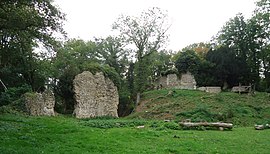 The motte and castle ruins in Avrilly | |
 Chambois  Chambois | |
Coordinates:  48°55′48″N 1°08′31″E / 48.930°N 1.142°E / 48.930; 1.142Coordinates: 48°55′48″N 1°08′31″E / 48.930°N 1.142°E / 48.930; 1.142 48°55′48″N 1°08′31″E / 48.930°N 1.142°E / 48.930; 1.142Coordinates: 48°55′48″N 1°08′31″E / 48.930°N 1.142°E / 48.930; 1.142 | |
| Country | France |
| Region | Normandy |
| Department | Eure |
| Arrondissement | Bernay |
| Canton | Verneuil d'Avre et d'Iton |
| Area 1 | 27.60 km2 (10.66 sq mi) |
| Population (Jan. 2018)[1] | 1,389 |
| • Density | 50/km2 (130/sq mi) |
| Time zone | UTC+01:00 (CET) |
| • Summer (DST) | UTC+02:00 (CEST) |
| INSEE/Postal code | 27032 /27240 |
| 1 French Land Register data, which excludes lakes, ponds, glaciers > 1 km2 (0.386 sq mi or 247 acres) and river estuaries. | |

Chambois is a commune in the department of Eure, northern France. The municipality was established on 1 January 2016 by merger of the former communes of Avrilly, Corneuil and Thomer-la-Sôgne.[2]
See also[]
- Communes of the Eure department
References[]
| Wikimedia Commons has media related to Chambois (Eure). |
- ^ "Populations légales 2018". INSEE. 28 December 2020.
- ^ Arrêté préfectoral 23 November 2015 (in French)
show
Communes of the Eure department | |
|---|---|
|
| Authority control |
|
|---|
This Eure geographical article is a stub. You can help Wikipedia by . |
- v
- t
Retrieved from ""
Categories:
- Communes of Eure
- Populated places established in 2016
- 2016 establishments in France
- Eure geography stubs
Hidden categories:
- Articles with French-language sources (fr)
- Articles with short description
- Short description is different from Wikidata
- Infobox mapframe without OSM relation ID on Wikidata
- Coordinates on Wikidata
- Pages using infobox settlement with image map1 but not image map
- Commons category link is on Wikidata
- Articles with VIAF identifiers
- Articles with WorldCat-VIAF identifiers
- All stub articles
- Pages using the Kartographer extension