Fresne-Cauverville
From Wikipedia, the free encyclopedia
Commune in Normandy, France
Fresne-Cauverville | |
|---|---|
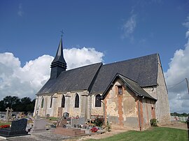 The church in Fresne-Cauverville | |
 Fresne-Cauverville  Fresne-Cauverville | |
Coordinates:  49°12′07″N 0°27′55″E / 49.2019°N 0.4653°E / 49.2019; 0.4653Coordinates: 49°12′07″N 0°27′55″E / 49.2019°N 0.4653°E / 49.2019; 0.4653 49°12′07″N 0°27′55″E / 49.2019°N 0.4653°E / 49.2019; 0.4653Coordinates: 49°12′07″N 0°27′55″E / 49.2019°N 0.4653°E / 49.2019; 0.4653 | |
| Country | France |
| Region | Normandy |
| Department | Eure |
| Arrondissement | Bernay |
| Canton | Beuzeville |
| Government | |
| • Mayor (2020–2026) | Didier Trefouel |
| Area 1 | 6.15 km2 (2.37 sq mi) |
| Population (Jan. 2018)[1] | 196 |
| • Density | 32/km2 (83/sq mi) |
| Time zone | UTC+01:00 (CET) |
| • Summer (DST) | UTC+02:00 (CEST) |
| INSEE/Postal code | 27269 /27260 |
| Elevation | 123–173 m (404–568 ft) (avg. 165 m or 541 ft) |
| 1 French Land Register data, which excludes lakes, ponds, glaciers > 1 km2 (0.386 sq mi or 247 acres) and river estuaries. | |

Fresne-Cauverville (French pronunciation: [fʁɛn kovɛʁvil]) is a commune in the Eure department in the Normandy region in northern France.
Population[]
| Year | Pop. | ±% |
|---|---|---|
| 1962 | 135 | — |
| 1968 | 158 | +17.0% |
| 1975 | 154 | −2.5% |
| 1982 | 171 | +11.0% |
| 1990 | 171 | +0.0% |
| 1999 | 161 | −5.8% |
| 2008 | 201 | +24.8% |
| 2016 | 203 | +1.0% |
See also[]
- Communes of the Eure department
References[]
- ^ "Populations légales 2018". INSEE. 28 December 2020.
| Wikimedia Commons has media related to Fresne-Cauverville. |
show
Communes of the Eure department | |
|---|---|
|
This Eure geographical article is a stub. You can help Wikipedia by . |
- v
- t
Retrieved from ""
Categories:
- Communes of Eure
- Eure geography stubs
Hidden categories:
- Articles with short description
- Short description is different from Wikidata
- Infobox mapframe without OSM relation ID on Wikidata
- Coordinates on Wikidata
- Pages using infobox settlement with image map1 but not image map
- Commons category link from Wikidata
- Articles with BNF identifiers
- All stub articles
- Pages using the Kartographer extension