Heudicourt, Eure
Heudicourt | |
|---|---|
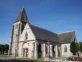 The church in Heudicourt | |
show Location of Heudicourt | |
 Heudicourt | |
| Coordinates: 49°20′17″N 1°39′39″E / 49.3381°N 1.6608°ECoordinates: 49°20′17″N 1°39′39″E / 49.3381°N 1.6608°E | |
| Country | France |
| Region | Normandy |
| Department | Eure |
| Arrondissement | Les Andelys |
| Canton | Gisors |
| Government | |
| • Mayor (2008–2014) | Yves Estève |
| Area 1 | 10.73 km2 (4.14 sq mi) |
| Population (Jan. 2018)[1] | 703 |
| • Density | 66/km2 (170/sq mi) |
| Time zone | UTC+01:00 (CET) |
| • Summer (DST) | UTC+02:00 (CEST) |
| INSEE/Postal code | 27333 /27860 |
| Elevation | 87–123 m (285–404 ft) (avg. 120 m or 390 ft) |
| 1 French Land Register data, which excludes lakes, ponds, glaciers > 1 km2 (0.386 sq mi or 247 acres) and river estuaries. | |


Heudicourt is a commune in the Eure department in northern France.
Population[]
| Year | Pop. | ±% |
|---|---|---|
| 1793 | 830 | — |
| 1800 | 790 | −4.8% |
| 1806 | 760 | −3.8% |
| 1821 | 746 | −1.8% |
| 1831 | 745 | −0.1% |
| 1836 | 762 | +2.3% |
| 1841 | 765 | +0.4% |
| 1846 | 780 | +2.0% |
| 1851 | 807 | +3.5% |
| 1856 | 777 | −3.7% |
| 1861 | 732 | −5.8% |
| 1866 | 673 | −8.1% |
| 1872 | 614 | −8.8% |
| 1876 | 623 | +1.5% |
| 1881 | 590 | −5.3% |
| 1886 | 581 | −1.5% |
| 1891 | 507 | −12.7% |
| 1896 | 480 | −5.3% |
| 1901 | 450 | −6.2% |
| 1906 | 438 | −2.7% |
| 1911 | 437 | −0.2% |
| 1921 | 369 | −15.6% |
| 1926 | 362 | −1.9% |
| 1931 | 347 | −4.1% |
| 1936 | 347 | +0.0% |
| 1946 | 381 | +9.8% |
| 1954 | 397 | +4.2% |
| 1962 | 428 | +7.8% |
| 1968 | 441 | +3.0% |
| 1975 | 389 | −11.8% |
| 1982 | 392 | +0.8% |
| 1990 | 519 | +32.4% |
| 1999 | 535 | +3.1% |
| 2008 | 618 | +15.5% |
See also[]
- Communes of the Eure department
References[]
- ^ "Populations légales 2018". INSEE. 28 December 2020.
| Wikimedia Commons has media related to Heudicourt (Eure). |
| show Communes of the Eure department |
|---|
This Eure geographical article is a stub. You can help Wikipedia by . |
Categories:
- Communes of Eure
- Eure geography stubs