Houlbec-Cocherel
Houlbec-Cocherel | |
|---|---|
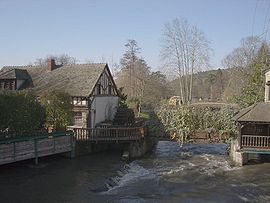 Mill of Cocherel | |
show Location of Houlbec-Cocherel | |
 Houlbec-Cocherel | |
| Coordinates: 49°04′29″N 1°21′53″E / 49.0747°N 1.3647°ECoordinates: 49°04′29″N 1°21′53″E / 49.0747°N 1.3647°E | |
| Country | France |
| Region | Normandy |
| Department | Eure |
| Arrondissement | Les Andelys |
| Canton | Pacy-sur-Eure |
| Government | |
| • Mayor (2020–2026) | Moïse Caron |
| Area 1 | 11.64 km2 (4.49 sq mi) |
| Population (Jan. 2018)[1] | 1,293 |
| • Density | 110/km2 (290/sq mi) |
| Time zone | UTC+01:00 (CET) |
| • Summer (DST) | UTC+02:00 (CEST) |
| INSEE/Postal code | 27343 /27120 |
| Elevation | 35–143 m (115–469 ft) (avg. 142 m or 466 ft) |
| 1 French Land Register data, which excludes lakes, ponds, glaciers > 1 km2 (0.386 sq mi or 247 acres) and river estuaries. | |


Houlbec-Cocherel (French pronunciation: [ulbɛk kɔʃʁɛl]) is a commune in the Eure department in Haute Normandie in northern France. The town is located 80 km away from the capital and most populous city in France, Paris.
History[]
The Battle of Cocherel, an event of the Hundred Years' War that occurred on 16 May 1364.
Population[]
| Year | Pop. | ±% |
|---|---|---|
| 1962 | 341 | — |
| 1968 | 407 | +19.4% |
| 1975 | 460 | +13.0% |
| 1982 | 859 | +86.7% |
| 1990 | 1,127 | +31.2% |
| 1999 | 1,188 | +5.4% |
| 2008 | 1,345 | +13.2% |
See also[]
- Communes of the Eure department
References[]
- ^ "Populations légales 2018". INSEE. 28 December 2020.
| Wikimedia Commons has media related to Houlbec-Cocherel. |
| show Communes of the Eure department |
|---|
| show Authority control |
|---|
This Eure geographical article is a stub. You can help Wikipedia by . |
Categories:
- Communes of Eure
- Eure geography stubs