Le Haut-Bréda
Le Haut-Bréda | |
|---|---|
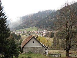 A general view of La Ferrière | |
Location of Le Haut-Bréda  | |
 Le Haut-Bréda | |
| Coordinates: 45°19′14″N 6°05′16″E / 45.3206°N 6.0878°ECoordinates: 45°19′14″N 6°05′16″E / 45.3206°N 6.0878°E | |
| Country | France |
| Region | Auvergne-Rhône-Alpes |
| Department | Isère |
| Arrondissement | Grenoble |
| Canton | Le Haut-Grésivaudan |
| Intercommunality | CC Le Grésivaudan |
| Area 1 | 78.60 km2 (30.35 sq mi) |
| Population (Jan. 2018)[1] | 393 |
| • Density | 5.0/km2 (13/sq mi) |
| Time zone | UTC+01:00 (CET) |
| • Summer (DST) | UTC+02:00 (CEST) |
| INSEE/Postal code | 38163 /38580 |
| Elevation | 551–2,928 m (1,808–9,606 ft) |
| 1 French Land Register data, which excludes lakes, ponds, glaciers > 1 km2 (0.386 sq mi or 247 acres) and river estuaries. | |


Le Haut-Bréda is a commune in the Isère department in southeastern France. It was established on 1 January 2019 by merger of the former communes of La Ferrière (the seat) and Pinsot.[2]
See also[]
References[]
- ^ "Populations légales 2018". The National Institute of Statistics and Economic Studies. 28 December 2020.
- ^ Arrêté préfectoral 18 December 2018 (in French)
| Wikimedia Commons has media related to Le Haut-Bréda. |
This Isère geographical article is a stub. You can help Wikipedia by . |
Categories:
- Communes of Isère
- Isère geography stubs