Saint-Lattier
show This article may be expanded with text translated from the corresponding article in French. (December 2009) Click [show] for important translation instructions. |
Saint-Lattier | |
|---|---|
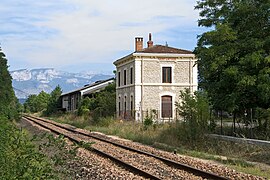 Train station | |
show Location of Saint-Lattier | |
 Saint-Lattier | |
| Coordinates: 45°05′19″N 5°12′05″E / 45.0886°N 5.2014°ECoordinates: 45°05′19″N 5°12′05″E / 45.0886°N 5.2014°E | |
| Country | France |
| Region | Auvergne-Rhône-Alpes |
| Department | Isère |
| Arrondissement | Grenoble |
| Canton | Le Sud Grésivaudan |
| Government | |
| • Mayor (2020–2026) | Raymond Payen[1] |
| Area 1 | 18.17 km2 (7.02 sq mi) |
| Population (Jan. 2018)[2] | 1,366 |
| • Density | 75/km2 (190/sq mi) |
| Time zone | UTC+01:00 (CET) |
| • Summer (DST) | UTC+02:00 (CEST) |
| INSEE/Postal code | 38410 /38840 |
| Elevation | 144–406 m (472–1,332 ft) (avg. 178 m or 584 ft) |
| 1 French Land Register data, which excludes lakes, ponds, glaciers > 1 km2 (0.386 sq mi or 247 acres) and river estuaries. | |


Saint-Lattier is a commune in the Isère department in southeastern France.
Population[]
|
|
See also[]
References[]
- ^ "Répertoire national des élus: les maires". data.gouv.fr, Plateforme ouverte des données publiques françaises (in French). 2 December 2020.
- ^ "Populations légales 2018". INSEE. 28 December 2020.
| Wikimedia Commons has media related to Saint-Lattier. |
This Isère geographical article is a stub. You can help Wikipedia by . |
Categories:
- Communes of Isère
- Isère geography stubs