Saint-Gervais, Isère
show This article may be expanded with text translated from the corresponding article in French. (December 2009) Click [show] for important translation instructions. |
Saint-Gervais | |
|---|---|
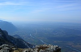 Saint-Gervais and Rovon to the left of the Isère, seen from la Cheminée (Vercors). | |
show Location of Saint-Gervais | |
 Saint-Gervais | |
| Coordinates: 45°12′09″N 5°28′58″E / 45.2025°N 5.4828°ECoordinates: 45°12′09″N 5°28′58″E / 45.2025°N 5.4828°E | |
| Country | France |
| Region | Auvergne-Rhône-Alpes |
| Department | Isère |
| Arrondissement | Grenoble |
| Canton | Le Sud Grésivaudan |
| Government | |
| • Mayor (2014–2020) | Monique Faure |
| Area 1 | 13.15 km2 (5.08 sq mi) |
| Population (Jan. 2018)[1] | 540 |
| • Density | 41/km2 (110/sq mi) |
| Time zone | UTC+01:00 (CET) |
| • Summer (DST) | UTC+02:00 (CEST) |
| INSEE/Postal code | 38390 /38470 |
| Elevation | 178–1,536 m (584–5,039 ft) |
| 1 French Land Register data, which excludes lakes, ponds, glaciers > 1 km2 (0.386 sq mi or 247 acres) and river estuaries. | |


Saint-Gervais is a commune in the Isère department in southeastern France.
Population[]
| Year | Pop. | ±% |
|---|---|---|
| 1793 | 469 | — |
| 1806 | 557 | +18.8% |
| 1821 | 569 | +2.2% |
| 1831 | 628 | +10.4% |
| 1841 | 709 | +12.9% |
| 1851 | 610 | −14.0% |
| 1861 | 657 | +7.7% |
| 1872 | 483 | −26.5% |
| 1881 | 432 | −10.6% |
| 1891 | 431 | −0.2% |
| 1901 | 389 | −9.7% |
| 1911 | 406 | +4.4% |
| 1921 | 388 | −4.4% |
| 1931 | 325 | −16.2% |
| 1946 | 341 | +4.9% |
| 1954 | 324 | −5.0% |
| 1962 | 366 | +13.0% |
| 1968 | 298 | −18.6% |
| 1975 | 256 | −14.1% |
| 1982 | 288 | +12.5% |
| 1990 | 295 | +2.4% |
| 1999 | 377 | +27.8% |
| 2006 | 512 | +35.8% |
| 2011 | 567 | +10.7% |
See also[]
References[]
| Wikimedia Commons has media related to Saint-Gervais (Isère). |
- ^ "Populations légales 2018". INSEE. 28 December 2020.
| show Authority control |
|---|
This Isère geographical article is a stub. You can help Wikipedia by . |
Categories:
- Communes of Isère
- Isère geography stubs