Saint-Pierre-de-Chérennes
show This article may be expanded with text translated from the corresponding article in French. (December 2009) Click [show] for important translation instructions. |
Saint-Pierre-de-Chérennes | |
|---|---|
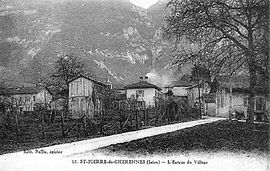 Saint-Pierre-de-Chérennes at the start of the 20th century | |
show Location of Saint-Pierre-de-Chérennes | |
 Saint-Pierre-de-Chérennes | |
| Coordinates: 45°07′19″N 5°21′47″E / 45.1219°N 5.3631°ECoordinates: 45°07′19″N 5°21′47″E / 45.1219°N 5.3631°E | |
| Country | France |
| Region | Auvergne-Rhône-Alpes |
| Department | Isère |
| Arrondissement | Grenoble |
| Canton | Le Sud Grésivaudan |
| Government | |
| • Mayor (2020–2026) | André Romey[1] |
| Area 1 | 12.03 km2 (4.64 sq mi) |
| Population (Jan. 2018)[2] | 462 |
| • Density | 38/km2 (99/sq mi) |
| Time zone | UTC+01:00 (CET) |
| • Summer (DST) | UTC+02:00 (CEST) |
| INSEE/Postal code | 38443 /38160 |
| Elevation | 170–1,400 m (560–4,590 ft) (avg. 303 m or 994 ft) |
| 1 French Land Register data, which excludes lakes, ponds, glaciers > 1 km2 (0.386 sq mi or 247 acres) and river estuaries. | |


Saint-Pierre-de-Chérennes (French pronunciation: [sɛ̃ pjɛʁ də ʃeʁɛn]) is a commune in the Isère department in southeastern France.
Population[]
|
|
See also[]
References[]
| Wikimedia Commons has media related to Saint-Pierre-de-Chérennes. |
- ^ "Répertoire national des élus: les maires". data.gouv.fr, Plateforme ouverte des données publiques françaises (in French). 2 December 2020.
- ^ "Populations légales 2018". INSEE. 28 December 2020.
This Isère geographical article is a stub. You can help Wikipedia by . |
Categories:
- Communes of Isère
- Isère geography stubs