Saint-Paul-d'Izeaux
show This article may be expanded with text translated from the corresponding article in French. (December 2009) Click [show] for important translation instructions. |
Saint-Paul-d'Izeaux | |
|---|---|
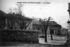 Saint-Paul-d'Izeaux in 1910 | |
show Location of Saint-Paul-d'Izeaux | |
 Saint-Paul-d'Izeaux | |
| Coordinates: 45°19′03″N 5°25′49″E / 45.3175°N 5.4303°ECoordinates: 45°19′03″N 5°25′49″E / 45.3175°N 5.4303°E | |
| Country | France |
| Region | Auvergne-Rhône-Alpes |
| Department | Isère |
| Arrondissement | Vienne |
| Canton | Bièvre |
| Intercommunality | Bièvre Isère |
| Government | |
| • Mayor (2014–2020) | Maurice André-Poyaud |
| Area 1 | 7.63 km2 (2.95 sq mi) |
| Population (Jan. 2018)[1] | 293 |
| • Density | 38/km2 (99/sq mi) |
| Time zone | UTC+01:00 (CET) |
| • Summer (DST) | UTC+02:00 (CEST) |
| INSEE/Postal code | 38437 /38140 |
| Elevation | 458–764 m (1,503–2,507 ft) (avg. 500 m or 1,600 ft) |
| 1 French Land Register data, which excludes lakes, ponds, glaciers > 1 km2 (0.386 sq mi or 247 acres) and river estuaries. | |


Saint-Paul-d'Izeaux is a commune in the Isère department in southeastern France.
Population[]
|
|
See also[]
References[]
| Wikimedia Commons has media related to Saint-Paul-d'Izeaux. |
- ^ "Populations légales 2018". INSEE. 28 December 2020.
| show Authority control |
|---|
This Isère geographical article is a stub. You can help Wikipedia by . |
Categories:
- Communes of Isère
- Isère geography stubs