Mont-Saint-Martin, Isère
Mont-Saint-Martin | |
|---|---|
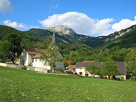 The village of Mont-Saint-Martin | |
show Location of Mont-Saint-Martin | |
 Mont-Saint-Martin | |
| Coordinates: 45°16′20″N 5°40′33″E / 45.2722°N 5.6758°ECoordinates: 45°16′20″N 5°40′33″E / 45.2722°N 5.6758°E | |
| Country | France |
| Region | Auvergne-Rhône-Alpes |
| Department | Isère |
| Arrondissement | Grenoble |
| Canton | Grenoble-2 |
| Intercommunality | Grenoble-Alpes Métropole |
| Government | |
| • Mayor (2020–2026) | Vincent Lecourt |
| Area 1 | 5 km2 (2 sq mi) |
| Population (Jan. 2018)[1] | 77 |
| • Density | 15/km2 (40/sq mi) |
| Time zone | UTC+01:00 (CET) |
| • Summer (DST) | UTC+02:00 (CEST) |
| INSEE/Postal code | 38258 /38120 |
| Elevation | 520–1,844 m (1,706–6,050 ft) (avg. 760 m or 2,490 ft) |
| 1 French Land Register data, which excludes lakes, ponds, glaciers > 1 km2 (0.386 sq mi or 247 acres) and river estuaries. | |


show This article may be expanded with text translated from the corresponding article in French. (December 2009) Click [show] for important translation instructions. |
Mont-Saint-Martin (French pronunciation: [mɔ̃ sɛ̃ maʁtɛ̃] (![]() listen); Arpitan: Mont-Sant-Martin) is a commune in the Isère department in southeastern France.
listen); Arpitan: Mont-Sant-Martin) is a commune in the Isère department in southeastern France.
Population[]
| Year | Pop. | ±% |
|---|---|---|
| 1800 | 121 | — |
| 1806 | 150 | +24.0% |
| 1821 | 143 | −4.7% |
| 1831 | 131 | −8.4% |
| 1841 | 133 | +1.5% |
| 1851 | 116 | −12.8% |
| 1861 | 115 | −0.9% |
| 1872 | 97 | −15.7% |
| 1881 | 98 | +1.0% |
| 1891 | 91 | −7.1% |
| 1901 | 76 | −16.5% |
| 1911 | 69 | −9.2% |
| 1921 | 53 | −23.2% |
| 1931 | 38 | −28.3% |
| 1946 | 49 | +28.9% |
| 1954 | 56 | +14.3% |
| 1962 | 35 | −37.5% |
| 1968 | 20 | −42.9% |
| 1975 | 45 | +125.0% |
| 1982 | 77 | +71.1% |
| 1990 | 77 | +0.0% |
| 1999 | 98 | +27.3% |
| 2006 | 94 | −4.1% |
| 2011 | 85 | −9.6% |
See also[]
References[]
- ^ "Populations légales 2018". INSEE. 28 December 2020.
| Wikimedia Commons has media related to Mont-Saint-Martin (Isère). |
This Isère geographical article is a stub. You can help Wikipedia by . |
Categories:
- Communes of Isère
- Isère geography stubs