Radepont
Radepont | |
|---|---|
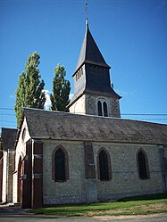 The church in Radepont | |
show Location of Radepont | |
 Radepont | |
| Coordinates: 49°21′07″N 1°19′45″E / 49.3519°N 1.3292°ECoordinates: 49°21′07″N 1°19′45″E / 49.3519°N 1.3292°E | |
| Country | France |
| Region | Normandy |
| Department | Eure |
| Arrondissement | Les Andelys |
| Canton | Romilly-sur-Andelle |
| Intercommunality | |
| Government | |
| • Mayor (2020–2026) | Patrick Minier[1] |
| Area 1 | 15.81 km2 (6.10 sq mi) |
| Population (Jan. 2018)[2] | 657 |
| • Density | 42/km2 (110/sq mi) |
| Time zone | UTC+01:00 (CET) |
| • Summer (DST) | UTC+02:00 (CEST) |
| INSEE/Postal code | 27487 /27380 |
| Elevation | 18–156 m (59–512 ft) (avg. 33 m or 108 ft) |
| 1 French Land Register data, which excludes lakes, ponds, glaciers > 1 km2 (0.386 sq mi or 247 acres) and river estuaries. | |


Radepont (French pronunciation: [ʁadpɔ̃]) is a commune in the Eure department in Normandy, northern France.
It is located 22 km south west of Rouen, on the river Andelle.
History[]
Radepont's monuments include the chateau de Radepont[3] and the ruined Cistercian abbey of [4]
The abbey was founded in 1185 by .[5] In the 12th century Radepont passed from the ownership of the Abbey of Les Préaux to . In 1194, Richard the Lion Heart had a castle built on this land.
Population[]
| Year | Pop. | ±% |
|---|---|---|
| 2006 | 756 | — |
| 2007 | 760 | +0.5% |
| 2008 | 757 | −0.4% |
| 2009 | 751 | −0.8% |
| 2010 | 746 | −0.7% |
| 2011 | 741 | −0.7% |
| 2012 | 684 | −7.7% |
| 2013 | 679 | −0.7% |
| 2014 | 671 | −1.2% |
| 2015 | 663 | −1.2% |
| 2016 | 655 | −1.2% |
See also[]
- Communes of the Eure department
References[]
| Wikimedia Commons has media related to Radepont. |
- ^ "Répertoire national des élus: les maires". data.gouv.fr, Plateforme ouverte des données publiques françaises (in French). 2 December 2020.
- ^ "Populations légales 2018". INSEE. 28 December 2020.
- ^ "chateau de radepont, normandy, France". Flickr. Retrieved 2016-07-27.
- ^ fr:Abbaye Notre-Dame de Fontaine-Guérard
- ^ fr:Radepont
| show Communes of the Eure department |
|---|
This Eure geographical article is a stub. You can help Wikipedia by . |
Categories:
- Communes of Eure
- Eure geography stubs