Rostrenen
Rostrenen
Rostrenenn | |
|---|---|
 The church of Notre-Dame du Roncier in Rostrenen | |
 Coat of arms | |
show Location of Rostrenen | |
 Rostrenen | |
| Coordinates: 48°14′14″N 3°18′56″W / 48.2372°N 3.3155°WCoordinates: 48°14′14″N 3°18′56″W / 48.2372°N 3.3155°W | |
| Country | France |
| Region | Brittany |
| Department | Côtes-d'Armor |
| Arrondissement | Guingamp |
| Canton | Rostrenen |
| Intercommunality | Kreiz-Breizh |
| Government | |
| • Mayor (2020–2026) | Guillaume Robic |
| Area 1 | 32.17 km2 (12.42 sq mi) |
| Population (Jan. 2018)[1] | 3,059 |
| • Density | 95/km2 (250/sq mi) |
| Time zone | UTC+01:00 (CET) |
| • Summer (DST) | UTC+02:00 (CEST) |
| INSEE/Postal code | 22266 /22110 |
| Elevation | 152–262 m (499–860 ft) |
| 1 French Land Register data, which excludes lakes, ponds, glaciers > 1 km2 (0.386 sq mi or 247 acres) and river estuaries. | |


Rostrenen (French pronunciation: [ʁɔstʁənɛ̃]; Breton: Rostrenenn) is a commune in the Côtes-d'Armor department and Brittany region of northwestern France.
Population[]
| Year | Pop. | ±% |
|---|---|---|
| 1946 | 2,534 | — |
| 1954 | 2,267 | −10.5% |
| 1962 | 1,924 | −15.1% |
| 1968 | 2,083 | +8.3% |
| 1975 | 3,875 | +86.0% |
| 1982 | 3,868 | −0.2% |
| 1990 | 3,664 | −5.3% |
| 1999 | 3,616 | −1.3% |
| 2006 | 3,397 | −6.1% |
| 2016 | 3,062 | −9.9% |
In French the inhabitants of Rostrenen are known as Rostrenois.
Breton language[]
On 13 September 2004 the municipality launched a linguistic plan as part of the Ya d'ar brezhoneg (Yes to Breton) campaign. In 2008, 34.5% of primary children attended bilingual schools.[2]
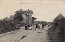 The former railway station (1898–1967) |
See also[]
References[]
- ^ "Populations légales 2018". INSEE. 28 December 2020.
- ^ (in French) Ofis ar Brezhoneg: Enseignement bilingue
External links[]
| Wikimedia Commons has media related to Rostrenen. |
- Official website (in French)
- Base Mérimée: Search for heritage in the commune, Ministère français de la Culture. (in French)
| show Authority control |
|---|
This Côtes-d'Armor geographical article is a stub. You can help Wikipedia by . |
Categories:
- Communes of Côtes-d'Armor
- Côtes-d'Armor geography stubs