Sainte-Opportune-du-Bosc
Sainte-Opportune-du-Bosc | |
|---|---|
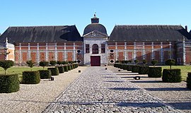 The entrance to the Chateau du Champ-de-Bataille, in Sainte-Opportune-du-Bosc | |
show Location of Sainte-Opportune-du-Bosc | |
 Sainte-Opportune-du-Bosc | |
| Coordinates: 49°09′42″N 0°50′17″E / 49.1617°N 0.8381°ECoordinates: 49°09′42″N 0°50′17″E / 49.1617°N 0.8381°E | |
| Country | France |
| Region | Normandy |
| Department | Eure |
| Arrondissement | Bernay |
| Canton | Brionne |
| Government | |
| • Mayor (2008–2014) | Simonne Pimont |
| Area 1 | 8.07 km2 (3.12 sq mi) |
| Population (Jan. 2018)[1] | 641 |
| • Density | 79/km2 (210/sq mi) |
| Time zone | UTC+01:00 (CET) |
| • Summer (DST) | UTC+02:00 (CEST) |
| INSEE/Postal code | 27576 /27110 |
| Elevation | 97–150 m (318–492 ft) |
| 1 French Land Register data, which excludes lakes, ponds, glaciers > 1 km2 (0.386 sq mi or 247 acres) and river estuaries. | |


Sainte-Opportune-du-Bosc is a commune in the Eure department in Normandy in northern France.
History[]
In 935 a big battle between William I, Duke of Normandy and Robert II took place near the town. The battlefield was called Champ-de-Bataille later and in the 17th century the Marshall of Créqui built a castle there.[2]
The Château du Champ de Bataille was owned by the Harcourt family and has formal gardens designed by Le Nôtre.
Population[]
| Year | Pop. | ±% |
|---|---|---|
| 1962 | 148 | — |
| 1968 | 145 | −2.0% |
| 1975 | 141 | −2.8% |
| 1982 | 192 | +36.2% |
| 1990 | 278 | +44.8% |
| 1999 | 334 | +20.1% |
| 2008 | 628 | +88.0% |

Château du Champ-de-Bataille

Detail of the garden of the castle


See also[]
- Communes of the Eure department
References[]
- ^ "Populations légales 2018". INSEE. 28 December 2020.
- ^ Château du Champ-de-Bataille (french)
| Wikimedia Commons has media related to Sainte-Opportune-du-Bosc. |
| show Communes of the Eure department |
|---|
This Eure geographical article is a stub. You can help Wikipedia by . |
Categories:
- Communes of Eure
- Eure geography stubs