Surtauville
Surtauville | |
|---|---|
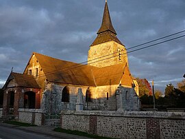 The church in Surtauville | |
show Location of Surtauville | |
 Surtauville | |
| Coordinates: 49°12′25″N 1°03′21″E / 49.2069°N 1.0558°ECoordinates: 49°12′25″N 1°03′21″E / 49.2069°N 1.0558°E | |
| Country | France |
| Region | Normandy |
| Department | Eure |
| Arrondissement | Les Andelys |
| Canton | Pont-de-l'Arche |
| Intercommunality | CA Seine-Eure |
| Government | |
| • Mayor (2020–2026) | Hervé Picard |
| Area 1 | 4.42 km2 (1.71 sq mi) |
| Population (Jan. 2018)[1] | 488 |
| • Density | 110/km2 (290/sq mi) |
| Time zone | UTC+01:00 (CET) |
| • Summer (DST) | UTC+02:00 (CEST) |
| INSEE/Postal code | 27623 /27400 |
| Elevation | 146–163 m (479–535 ft) (avg. 164 m or 538 ft) |
| 1 French Land Register data, which excludes lakes, ponds, glaciers > 1 km2 (0.386 sq mi or 247 acres) and river estuaries. | |


Surtauville (French pronunciation: [syʁtovil]) is a commune in the Eure department in Normandy in northern France.
Population[]
|
|
See also[]
- Communes of the Eure department
References[]
- ^ "Populations légales 2018". INSEE. 28 December 2020.
| Wikimedia Commons has media related to Surtauville. |
| show Communes of the Eure department |
|---|
This Eure geographical article is a stub. You can help Wikipedia by . |
Categories:
- Communes of Eure
- Eure geography stubs