Armix
Armix | |
|---|---|
Commune | |
 The road into Armix | |
show Location of Armix | |
 Armix | |
| Coordinates: 45°51′00″N 5°35′11″E / 45.85°N 5.5864°ECoordinates: 45°51′00″N 5°35′11″E / 45.85°N 5.5864°E | |
| Country | France |
| Region | Auvergne-Rhône-Alpes |
| Department | Ain |
| Arrondissement | Belley |
| Canton | Hauteville-Lompnes |
| Intercommunality | |
| Government | |
| • Mayor (2020–2026) | Véronique Vuilloud |
| Area 1 | 6.82 km2 (2.63 sq mi) |
| Population (Jan. 2018)[1] | 27 |
| • Density | 4.0/km2 (10/sq mi) |
| Time zone | UTC+01:00 (CET) |
| • Summer (DST) | UTC+02:00 (CEST) |
| INSEE/Postal code | 01019 /01510 |
| Elevation | 420–1,064 m (1,378–3,491 ft) (avg. 720 m or 2,360 ft) |
| 1 French Land Register data, which excludes lakes, ponds, glaciers > 1 km2 (0.386 sq mi or 247 acres) and river estuaries. | |


Armix is a commune in the Ain department in the Auvergne-Rhône-Alpes region of eastern France.
The inhabitants of the commune are known as Armixois or Armixoises[2]
Geography[]
Armix is located some 30 km south-east of Amberieu-en-Bugey and 40 km north-west of Aix-les-Bains. It can be accessed by road D103 from Rossillon in the south passing through the village and continuing north to Premillieu. There are few small mountain roads in the commune which is entirely mountainous and mostly forested.
The Ruisseau Pointay rises near the village and flows south joining the Ruisseau de la Chana which forms part of the southern border and continues south-west to join the Furans river.[3]
Administration[]
This list is incomplete; you can help by . (April 2021) |
List of mayors of Armix[4]
| From | To | Name |
|---|---|---|
| 1995 | 2001 | Georges Galley |
| 2001 | 2008 | Michel Miguet |
| 2008 | 2014 | Gérard Billon-Grand |
| 2014 | Present | Véronique Vuilloud |
Economy[]
The Economy of the commune of Armix is mostly Agriculture. The commune of Armix is located in the Rhone-Alpes, region in the department of Ain. The economy of the Rhone-Alpes region is based on raw materials, agriculture and energy.
Population[]
| Year | Pop. | ±% |
|---|---|---|
| 2005 | 24 | — |
| 2006 | 25 | +4.2% |
| 2007 | 25 | +0.0% |
| 2008 | 23 | −8.0% |
| 2009 | 22 | −4.3% |
| 2010 | 20 | −9.1% |
| 2011 | 20 | +0.0% |
| 2012 | 20 | +0.0% |
| 2013 | 21 | +5.0% |
| 2014 | 23 | +9.5% |
| 2015 | 24 | +4.3% |
| 2016 | 26 | +8.3% |

Armix Photo Gallery[]

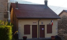
Armix Town Square

A street in Armix
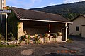
Armix Lavoir (Public Laundry)
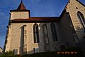
Armix Church


See also[]
References[]
- ^ "Populations légales 2018". INSEE. 28 December 2020.
- ^ Inhabitants of Ain (in French)
- ^ Jump up to: a b Google Maps
- ^ List of Mayors of France (in French)
External links[]
| Wikimedia Commons has media related to Armix. |
| show Authority control |
|---|
- Communes of Ain