Brouilla
Brouilla
Santa Maria de Brullà | |
|---|---|
 The church of Sainte-Marie, in Brouilla | |
show Location of Brouilla | |
 Brouilla | |
| Coordinates: 42°34′03″N 2°54′16″E / 42.5675°N 2.9044°ECoordinates: 42°34′03″N 2°54′16″E / 42.5675°N 2.9044°E | |
| Country | France |
| Region | Occitanie |
| Department | Pyrénées-Orientales |
| Arrondissement | Céret |
| Canton | Les Aspres |
| Intercommunality | Aspres |
| Government | |
| • Mayor (2020–2026) | Pierre Taurinya |
| Area 1 | 7.83 km2 (3.02 sq mi) |
| Population (Jan. 2018)[1] | 1,485 |
| • Density | 190/km2 (490/sq mi) |
| Time zone | UTC+01:00 (CET) |
| • Summer (DST) | UTC+02:00 (CEST) |
| INSEE/Postal code | 66026 /66620 |
| Elevation | 27–108 m (89–354 ft) (avg. 46 m or 151 ft) |
| 1 French Land Register data, which excludes lakes, ponds, glaciers > 1 km2 (0.386 sq mi or 247 acres) and river estuaries. | |


Brouilla (French pronunciation: [bʁuja] (![]() listen); Catalan: Brullà) is a commune in the Pyrénées-Orientales department in southern France.
listen); Catalan: Brullà) is a commune in the Pyrénées-Orientales department in southern France.
Geography[]
Localisation[]
Brouilla is located in the canton of Les Aspres and in the arrondissement of Perpignan.
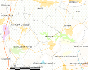
Map of Brouilla and its surrounding communes
| show Places adjacent to Brouilla |
|---|
Government and politics[]
Mayors[]
| Mayor | Term start | Term end |
|---|---|---|
| François Nègre | 1959 | 1971 |
| Michel Capdet | 1971 | 1991 |
| Roger Parada | 1991 | 1995 |
| Pierre Taurinya | 1995 |
Population[]
| Year | Pop. | ±% |
|---|---|---|
| 1962 | 530 | — |
| 1968 | 537 | +1.3% |
| 1975 | 564 | +5.0% |
| 1982 | 616 | +9.2% |
| 1990 | 565 | −8.3% |
| 1999 | 630 | +11.5% |
| 2007 | 990 | +57.1% |
| 2009 | 1,037 | +4.7% |
See also[]
References[]
- ^ "Populations légales 2018". INSEE. 28 December 2020.
| Wikimedia Commons has media related to Brouilla. |
This Pyrénées-Orientales geographical article is a stub. You can help Wikipedia by . |
Categories:
- Communes of Pyrénées-Orientales
- Pyrénées-Orientales geography stubs