Fillols
Fillols | |
|---|---|
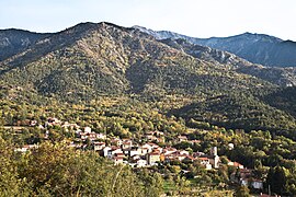 A general view of Fillols | |
show Location of Fillols | |
 Fillols | |
| Coordinates: 42°33′43″N 2°24′37″E / 42.5619°N 2.4103°ECoordinates: 42°33′43″N 2°24′37″E / 42.5619°N 2.4103°E | |
| Country | France |
| Region | Occitanie |
| Department | Pyrénées-Orientales |
| Arrondissement | Prades |
| Canton | Le Canigou |
| Government | |
| • Mayor (2020–2026) | Claude Escape |
| Area 1 | 8.40 km2 (3.24 sq mi) |
| Population (Jan. 2018)[1] | 187 |
| • Density | 22/km2 (58/sq mi) |
| Time zone | UTC+01:00 (CET) |
| • Summer (DST) | UTC+02:00 (CEST) |
| INSEE/Postal code | 66078 /66820 |
| Elevation | 576–2,360 m (1,890–7,743 ft) (avg. 650 m or 2,130 ft) |
| 1 French Land Register data, which excludes lakes, ponds, glaciers > 1 km2 (0.386 sq mi or 247 acres) and river estuaries. | |


Fillols (French pronunciation: [fijɔls] (![]() listen); Catalan: Fillols) is a commune in the Pyrénées-Orientales department in southern France.
listen); Catalan: Fillols) is a commune in the Pyrénées-Orientales department in southern France.
Geography[]
Fillols is located in the canton of Le Canigou and in the arrondissement of Prades.

Map of Fillols and its surrounding communes
Population[]
| Year | Pop. | ±% p.a. |
|---|---|---|
| 1968 | 187 | — |
| 1975 | 141 | −3.95% |
| 1982 | 163 | +2.09% |
| 1990 | 141 | −1.80% |
| 1999 | 141 | +0.00% |
| 2007 | 149 | +0.69% |
| 2012 | 169 | +2.55% |
| 2017 | 185 | +1.83% |
| Source: INSEE[2] | ||
See also[]
References[]
- ^ "Populations légales 2018". INSEE. 28 December 2020.
- ^ Population en historique depuis 1968, INSEE
| Wikimedia Commons has media related to Fillols (Pyrénées-Orientales). |
This Pyrénées-Orientales geographical article is a stub. You can help Wikipedia by . |
Categories:
- Communes of Pyrénées-Orientales
- Pyrénées-Orientales geography stubs