Saint-Pierre-dels-Forcats
Saint-Pierre-dels-Forcats
Sant Pere dels Forcats | |
|---|---|
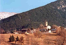 A view of Saint-Pierre-dels-Forcats, from La Cabanasse | |
 Coat of arms | |
show Location of Saint-Pierre-dels-Forcats | |
 Saint-Pierre-dels-Forcats | |
| Coordinates: 42°29′44″N 2°07′09″E / 42.4956°N 2.1192°ECoordinates: 42°29′44″N 2°07′09″E / 42.4956°N 2.1192°E | |
| Country | France |
| Region | Occitanie |
| Department | Pyrénées-Orientales |
| Arrondissement | Prades |
| Canton | Les Pyrénées catalanes |
| Government | |
| • Mayor (2020–2026) | Pierre Blanqué[1] |
| Area 1 | 12.81 km2 (4.95 sq mi) |
| Population (Jan. 2018)[2] | 264 |
| • Density | 21/km2 (53/sq mi) |
| Time zone | UTC+01:00 (CET) |
| • Summer (DST) | UTC+02:00 (CEST) |
| INSEE/Postal code | 66188 /66210 |
| Elevation | 1,320–2,750 m (4,330–9,020 ft) (avg. 1,571 m or 5,154 ft) |
| 1 French Land Register data, which excludes lakes, ponds, glaciers > 1 km2 (0.386 sq mi or 247 acres) and river estuaries. | |


Saint-Pierre-dels-Forcats (Catalan: Sant Pere del Forcats) is a commune in the Pyrénées-Orientales department in southern France.
Geography[]
Saint-Pierre-dels-Forcats is located in the canton of Les Pyrénées catalanes and in the arrondissement of Prades.

Map of Saint-Pierre-dels-Forcats and its surrounding communes
Population[]
| Year | Pop. | ±% p.a. |
|---|---|---|
| 1968 | 114 | — |
| 1975 | 166 | +5.52% |
| 1982 | 156 | −0.88% |
| 1990 | 185 | +2.15% |
| 1999 | 213 | +1.58% |
| 2007 | 233 | +1.13% |
| 2012 | 264 | +2.53% |
| 2017 | 267 | +0.23% |
| Source: INSEE[3] | ||
See also[]
References[]
- ^ "Répertoire national des élus: les maires". data.gouv.fr, Plateforme ouverte des données publiques françaises (in French). 2 December 2020. Retrieved 7 December 2020.
- ^ "Populations légales 2018". INSEE. 28 December 2020.
- ^ Population en historique depuis 1968, INSEE
| Wikimedia Commons has media related to Saint-Pierre-dels-Forcats. |
This Pyrénées-Orientales geographical article is a stub. You can help Wikipedia by . |
Categories:
- Communes of Pyrénées-Orientales
- Pyrénées-Orientales geography stubs