Rodès
Rodès
Rodés | |
|---|---|
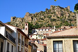 A view within the village of Rodès | |
 Coat of arms | |
show Location of Rodès | |
 Rodès | |
| Coordinates: 42°39′29″N 2°33′44″E / 42.6581°N 2.5622°ECoordinates: 42°39′29″N 2°33′44″E / 42.6581°N 2.5622°E | |
| Country | France |
| Region | Occitanie |
| Department | Pyrénées-Orientales |
| Arrondissement | Prades |
| Canton | Le Canigou |
| Intercommunality | Roussillon Conflent |
| Government | |
| • Mayor (2020–2026) | Marc Bianchini[1] |
| Area 1 | 18.11 km2 (6.99 sq mi) |
| Population (Jan. 2018)[2] | 624 |
| • Density | 34/km2 (89/sq mi) |
| Time zone | UTC+01:00 (CET) |
| • Summer (DST) | UTC+02:00 (CEST) |
| INSEE/Postal code | 66165 /66320 |
| Elevation | 172–771 m (564–2,530 ft) (avg. 200 m or 660 ft) |
| 1 French Land Register data, which excludes lakes, ponds, glaciers > 1 km2 (0.386 sq mi or 247 acres) and river estuaries. | |


Rodès (French pronunciation: [ʁodɛs] (![]() listen); Occitan: Rodès) is a commune in the Pyrénées-Orientales department in southern France.
listen); Occitan: Rodès) is a commune in the Pyrénées-Orientales department in southern France.
Geography[]
Rodès is in the canton of Le Canigou and in the arrondissement of Prades.

Map of Rodès and its surrounding communes
Population[]
| Year | Pop. | ±% p.a. |
|---|---|---|
| 1968 | 401 | — |
| 1975 | 340 | −2.33% |
| 1982 | 347 | +0.29% |
| 1990 | 407 | +2.01% |
| 1999 | 509 | +2.52% |
| 2007 | 597 | +2.01% |
| 2012 | 626 | +0.95% |
| 2017 | 619 | −0.22% |
| Source: INSEE[3] | ||
See also[]
References[]
- ^ "Répertoire national des élus: les maires". data.gouv.fr, Plateforme ouverte des données publiques françaises (in French). 2 December 2020. Retrieved 7 December 2020.
- ^ "Populations légales 2018". INSEE. 28 December 2020.
- ^ Population en historique depuis 1968, INSEE
| Wikimedia Commons has media related to Rodès. |
This Pyrénées-Orientales geographical article is a stub. You can help Wikipedia by . |
Categories:
- Communes of Pyrénées-Orientales
- Pyrénées-Orientales geography stubs