Prunet-et-Belpuig
Prunet-et-Belpuig
Prunet i Bellpuig | |
|---|---|
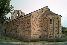 The Chapel of the Trinity, in Prunet-et-Belpuig | |
show Location of Prunet-et-Belpuig | |
 Prunet-et-Belpuig | |
| Coordinates: 42°33′46″N 2°37′32″E / 42.5628°N 2.6256°ECoordinates: 42°33′46″N 2°37′32″E / 42.5628°N 2.6256°E | |
| Country | France |
| Region | Occitanie |
| Department | Pyrénées-Orientales |
| Arrondissement | Prades |
| Canton | Le Canigou |
| Intercommunality | Roussillon Conflent |
| Government | |
| • Mayor (2020–2026) | Benoît Bonacaze |
| Area 1 | 21.68 km2 (8.37 sq mi) |
| Population (Jan. 2018)[1] | 49 |
| • Density | 2.3/km2 (5.9/sq mi) |
| Time zone | UTC+01:00 (CET) |
| • Summer (DST) | UTC+02:00 (CEST) |
| INSEE/Postal code | 66153 /66130 |
| Elevation | 353–863 m (1,158–2,831 ft) (avg. 660 m or 2,170 ft) |
| 1 French Land Register data, which excludes lakes, ponds, glaciers > 1 km2 (0.386 sq mi or 247 acres) and river estuaries. | |


Prunet-et-Belpuig (Catalan: Prunet i Bellpuig) is a commune in the Pyrénées-Orientales department in southern France.
Geography[]
Prunet-et-Belpuig is in the canton of Le Canigou and in the arrondissement of Prades.

Map of Prunet-et-Belpuig and its surrounding communes
Population[]
| Year | Pop. | ±% p.a. |
|---|---|---|
| 1968 | 55 | — |
| 1975 | 36 | −5.87% |
| 1982 | 37 | +0.39% |
| 1990 | 52 | +4.35% |
| 1999 | 68 | +3.03% |
| 2007 | 58 | −1.97% |
| 2012 | 54 | −1.42% |
| 2017 | 49 | −1.92% |
| Source: INSEE[2] | ||
See also[]
References[]
- ^ "Populations légales 2018". INSEE. 28 December 2020.
- ^ Population en historique depuis 1968, INSEE
| Wikimedia Commons has media related to Prunet-et-Belpuig. |
| show Authority control |
|---|
This Pyrénées-Orientales geographical article is a stub. You can help Wikipedia by . |
Categories:
- Communes of Pyrénées-Orientales
- Pyrénées-Orientales geography stubs