Nahuja
Nahuja
Naüja | |
|---|---|
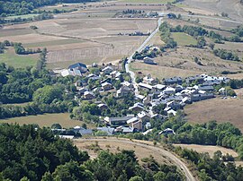 An aerial view of Nahuja | |
show Location of Nahuja | |
 Nahuja | |
| Coordinates: 42°25′33″N 1°59′45″E / 42.4258°N 1.9958°ECoordinates: 42°25′33″N 1°59′45″E / 42.4258°N 1.9958°E | |
| Country | France |
| Region | Occitanie |
| Department | Pyrénées-Orientales |
| Arrondissement | Prades |
| Canton | Les Pyrénées catalanes |
| Intercommunality | |
| Government | |
| • Mayor (2020–2026) | Francine Majoral[1] |
| Area 1 | 5.60 km2 (2.16 sq mi) |
| Population (Jan. 2018)[2] | 76 |
| • Density | 14/km2 (35/sq mi) |
| Time zone | UTC+01:00 (CET) |
| • Summer (DST) | UTC+02:00 (CEST) |
| INSEE/Postal code | 66120 /66340 |
| Elevation | 1,196–1,888 m (3,924–6,194 ft) (avg. 1,350 m or 4,430 ft) |
| 1 French Land Register data, which excludes lakes, ponds, glaciers > 1 km2 (0.386 sq mi or 247 acres) and river estuaries. | |


Nahuja (Catalan: Naüja) is a small village in the Cerdanya which is part of the Pyrénées-Orientales department in southern France. It is only 8 km far from the Spanish border in Puigcerdà. Its closest neighbour towns are Osséja and Sainte-Léocadie.
Geography[]
Nahuja is located in the canton of Les Pyrénées catalanes and in the arrondissement of Prades.

Map of Nahuja and its surrounding communes
Population[]
| Year | Pop. | ±% |
|---|---|---|
| 2005 | 73 | — |
| 2006 | 70 | −4.1% |
| 2007 | 69 | −1.4% |
| 2008 | 69 | +0.0% |
| 2009 | 68 | −1.4% |
| 2010 | 68 | +0.0% |
| 2011 | 67 | −1.5% |
| 2012 | 66 | −1.5% |
| 2013 | 69 | +4.5% |
| 2014 | 73 | +5.8% |
| 2015 | 76 | +4.1% |
| 2016 | 76 | +0.0% |
See also[]
References[]
- ^ "Répertoire national des élus: les maires". data.gouv.fr, Plateforme ouverte des données publiques françaises (in French). 2 December 2020.
- ^ "Populations légales 2018". INSEE. 28 December 2020.
| Wikimedia Commons has media related to Nahuja. |
This Pyrénées-Orientales geographical article is a stub. You can help Wikipedia by . |
Categories:
- Communes of Pyrénées-Orientales
- Pyrénées-Orientales geography stubs