Corneilla-la-Rivière
Corneilla-la-Rivière
Cornellà de la Ribera | |
|---|---|
 The town hall | |
 Coat of arms | |
show Location of Corneilla-la-Rivière | |
 Corneilla-la-Rivière | |
| Coordinates: 42°41′54″N 2°43′52″E / 42.6983°N 2.7311°ECoordinates: 42°41′54″N 2°43′52″E / 42.6983°N 2.7311°E | |
| Country | France |
| Region | Occitanie |
| Department | Pyrénées-Orientales |
| Arrondissement | Prades |
| Canton | La Vallée de la Têt |
| Intercommunality | Roussillon Conflent |
| Government | |
| • Mayor (2020–2026) | René Laville |
| Area 1 | 11.90 km2 (4.59 sq mi) |
| Population (Jan. 2018)[1] | 1,978 |
| • Density | 170/km2 (430/sq mi) |
| Time zone | UTC+01:00 (CET) |
| • Summer (DST) | UTC+02:00 (CEST) |
| INSEE/Postal code | 66058 /66550 |
| Elevation | 74–480 m (243–1,575 ft) (avg. 48 m or 157 ft) |
| 1 French Land Register data, which excludes lakes, ponds, glaciers > 1 km2 (0.386 sq mi or 247 acres) and river estuaries. | |


Corneilla-la-Rivière (French pronunciation: [kɔʁnɛja la ʁivjɛʁ] (![]() listen); Catalan: Cornellà de la Ribera) is a commune in the Pyrénées-Orientales department in southern France.
listen); Catalan: Cornellà de la Ribera) is a commune in the Pyrénées-Orientales department in southern France.
Geography[]
Localisation[]
Corneilla-la-Rivière is located in the canton of La Vallée de la Têt and in the arrondissement of Perpignan.
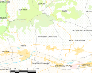
Map of Corneilla-la-Rivière and its surrounding communes
| show Places adjacent to Corneilla-la-Rivière |
|---|
Population[]
| Year | Pop. | ±% p.a. |
|---|---|---|
| 1968 | 1,010 | — |
| 1975 | 936 | −1.08% |
| 1982 | 967 | +0.47% |
| 1990 | 1,081 | +1.40% |
| 1999 | 1,407 | +2.97% |
| 2007 | 1,725 | +2.58% |
| 2012 | 1,953 | +2.51% |
| 2017 | 1,991 | +0.39% |
| Source: INSEE[2] | ||
See also[]
References[]
- ^ "Populations légales 2018". INSEE. 28 December 2020.
- ^ Population en historique depuis 1968, INSEE
| Wikimedia Commons has media related to Corneilla-la-Rivière. |
| show Authority control |
|---|
This Pyrénées-Orientales geographical article is a stub. You can help Wikipedia by . |
Categories:
- Communes of Pyrénées-Orientales
- Pyrénées-Orientales geography stubs