Fontrabiouse
Fontrabiouse
Font Rabiosa | |
|---|---|
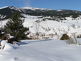 A general view of Fontrabiouse in the snow | |
show Location of Fontrabiouse | |
 Fontrabiouse | |
| Coordinates: 42°38′13″N 2°05′48″E / 42.6369°N 2.0967°ECoordinates: 42°38′13″N 2°05′48″E / 42.6369°N 2.0967°E | |
| Country | France |
| Region | Occitanie |
| Department | Pyrénées-Orientales |
| Arrondissement | Prades |
| Canton | Les Pyrénées catalanes |
| Government | |
| • Mayor (2020–2026) | Pierre Bataille[1] |
| Area 1 | 15.57 km2 (6.01 sq mi) |
| Population (Jan. 2018)[2] | 126 |
| • Density | 8.1/km2 (21/sq mi) |
| Time zone | UTC+01:00 (CET) |
| • Summer (DST) | UTC+02:00 (CEST) |
| INSEE/Postal code | 66081 /66210 |
| Elevation | 1,438–2,547 m (4,718–8,356 ft) (avg. 1,460 m or 4,790 ft) |
| 1 French Land Register data, which excludes lakes, ponds, glaciers > 1 km2 (0.386 sq mi or 247 acres) and river estuaries. | |


Fontrabiouse (Catalan: Font Rabiosa) is a commune in the Pyrénées-Orientales department in southern France.
Geography[]
Fontrabiouse is located in the canton of Les Pyrénées catalanes and in the arrondissement of Prades.

Map of Fontrabiouse and its surrounding communes
Population[]
| Year | Pop. | ±% p.a. |
|---|---|---|
| 1968 | 89 | — |
| 1975 | 96 | +1.09% |
| 1982 | 72 | −4.03% |
| 1990 | 76 | +0.68% |
| 1999 | 91 | +2.02% |
| 2007 | 109 | +2.28% |
| 2012 | 134 | +4.22% |
| 2017 | 127 | −1.07% |
| Source: INSEE[3] | ||
See also[]
References[]
- ^ "Répertoire national des élus: les maires". data.gouv.fr, Plateforme ouverte des données publiques françaises (in French). 2 December 2020.
- ^ "Populations légales 2018". INSEE. 28 December 2020.
- ^ Population en historique depuis 1968, INSEE
| Wikimedia Commons has media related to Fontrabiouse. |
This Pyrénées-Orientales geographical article is a stub. You can help Wikipedia by . |
Categories:
- Communes of Pyrénées-Orientales
- Pyrénées-Orientales geography stubs