Espira-de-l'Agly
Espira-de-l'Agly
Espirà de l'Aglí | |
|---|---|
 The town hall in Espira-de-l'Agly | |
 Coat of arms | |
show Location of Espira-de-l'Agly | |
 Espira-de-l'Agly | |
| Coordinates: 42°46′41″N 2°50′11″E / 42.7781°N 2.8364°ECoordinates: 42°46′41″N 2°50′11″E / 42.7781°N 2.8364°E | |
| Country | France |
| Region | Occitanie |
| Department | Pyrénées-Orientales |
| Arrondissement | Perpignan |
| Canton | La Vallée de l'Agly |
| Intercommunality | Perpignan Méditerranée Métropole |
| Government | |
| • Mayor (2020-2026) | Philippe Fourcade |
| Area 1 | 26.77 km2 (10.34 sq mi) |
| Population (Jan. 2018)[1] | 3,460 |
| • Density | 130/km2 (330/sq mi) |
| Time zone | UTC+01:00 (CET) |
| • Summer (DST) | UTC+02:00 (CEST) |
| INSEE/Postal code | 66069 /66600 |
| Elevation | 26–458 m (85–1,503 ft) (avg. 36 m or 118 ft) |
| 1 French Land Register data, which excludes lakes, ponds, glaciers > 1 km2 (0.386 sq mi or 247 acres) and river estuaries. | |


Espira-de-l'Agly (Catalan: Espirà de l'Aglí) is a commune in the Pyrénées-Orientales department in southern France.
Geography[]
Localisation[]
Espira-de-l'Agly is located in the canton of La Vallée de l'Agly and in the arrondissement of Perpignan. Espira-de-l'Agly is situated approximately 12 km outside Perpignan.
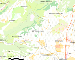
Map of Espira-de-l'Agly and its surrounding communes
| show Places adjacent to Espira-de-l'Agly |
|---|
Population[]
| Year | Pop. | ±% p.a. |
|---|---|---|
| 1968 | 1,685 | — |
| 1975 | 1,599 | −0.75% |
| 1982 | 1,723 | +1.07% |
| 1990 | 2,196 | +3.08% |
| 1999 | 2,463 | +1.28% |
| 2007 | 2,960 | +2.32% |
| 2012 | 3,304 | +2.22% |
| 2017 | 3,455 | +0.90% |
| Source: INSEE[2] | ||
See also[]
References[]
- ^ "Populations légales 2018". INSEE. 28 December 2020.
- ^ Population en historique depuis 1968, INSEE
| Wikimedia Commons has media related to Espira-de-l'Agly. |
| show Authority control |
|---|
This Pyrénées-Orientales geographical article is a stub. You can help Wikipedia by . |
Categories:
- Communes of Pyrénées-Orientales
- Pyrénées-Orientales geography stubs