L'Albère
L’Albère | |
|---|---|
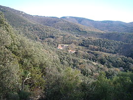 The hamlet of Saint-Jean seen from the trail leading to the dolmen of | |
show Location of L’Albère | |
 L’Albère | |
| Coordinates: 42°29′01″N 2°53′41″E / 42.4836°N 2.8947°ECoordinates: 42°29′01″N 2°53′41″E / 42.4836°N 2.8947°E | |
| Country | France |
| Region | Occitanie |
| Department | Pyrénées-Orientales |
| Arrondissement | Céret |
| Canton | Vallespir-Albères |
| Intercommunality | |
| Government | |
| • Mayor (2020-2026) | Marc de Besombes-Singla |
| Area 1 | 17.10 km2 (6.60 sq mi) |
| Population (Jan. 2018)[1] | 76 |
| • Density | 4.4/km2 (12/sq mi) |
| Time zone | UTC+01:00 (CET) |
| • Summer (DST) | UTC+02:00 (CEST) |
| INSEE/Postal code | 66001 /66480 |
| Elevation | 266–1,116 m (873–3,661 ft) (avg. 532 m or 1,745 ft) |
| 1 French Land Register data, which excludes lakes, ponds, glaciers > 1 km2 (0.386 sq mi or 247 acres) and river estuaries. | |


L'Albère (Catalan: L'Albera) is a commune in the Pyrénées-Orientales department in southern France.
Geography[]
Localisation[]
L'Albère is located in the canton of Vallespir-Albères and in the arrondissement of Céret.
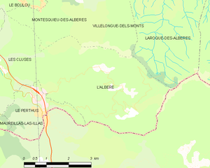
| show Places adjacent to L'Albère |
|---|
Toponymy[]
The name of L'Albère is clearly issued from the Albera Massif in which it is located. Although always plural in French (Albères) concerning the mountain range, the name remains singular through the ages (L'Albère) for the commune. On the contrary, in Catalan, the name has always been singular for both the mountain (Serra de l'Albera) and the place (L'Albera).[2] · [3]
History[]
Early settlements of population grew near the two primitive churches : Saint Martin, already named in 844 (cella Sancti Martini de Monte Furcato) and Saint John, known since 1089 (ecclesiae Sancti Ioannis de Albera). The hamlets of Saint Martin and Saint John both still exist nowadays, each with its church.[4]
Government and politics[]
Canton[]
In 1790, the commune of L'Albère is included into the canton of Argelès, then part of the Céret district. It is moved to the in 1793 and back to the canton of Argelès in 1801, before being finally included in the canton of Céret in 1947.[5] Following the French canton reorganisation which came into effect in March 2015, L'Albère is now part of the canton of Vallespir-Albères.[6]
Mayors[]
| Mayor | In office | Party | Notes | |
|---|---|---|---|---|
| Sylvestre Vilallongue | 1795 | 1801 | ||
| Jacques Oriol | 1802 | 1813 | ||
| Joseph Reste | 1813 | 1830 | ||
| Jacques Oriol | 1831 | 1834 | ||
| Joseph Reste fils | 1835 | 1877 | ||
| Albert Oriol | 1878 | 1884 | ||
| Gustave Tarres | 1885 | 1887 | ||
| Auguste Vinyes | 1888 | 1904 | ||
| Justin Besombes | 1904 | 1934 | ||
| Antoine de Besombes-Singla | 1935 | 1971 | ||
| Pierre de Besombes-Singla | March 1971 | April 2013 | ||
| Marc de Besombes-Singla | May 2013 | Incumbent | Son of previous mayor. | |
Population and society[]
Demography[]
| Year | Pop. | ±% |
|---|---|---|
| 2004 | 67 | — |
| 2006 | 69 | +3.0% |
| 2007 | 74 | +7.2% |
| 2008 | 78 | +5.4% |
| 2009 | 83 | +6.4% |
| 2010 | 83 | +0.0% |
| 2011 | 83 | +0.0% |
| 2012 | 82 | −1.2% |
| 2013 | 82 | +0.0% |
| 2014 | 81 | −1.2% |
| 2015 | 83 | +2.5% |
| 2016 | 83 | +0.0% |
Education[]
There is no school in L'Albère. The nearest is in Le Perthus.
Events[]
- Patronal feast : 5 August.
- Communal feast : 2nd Sunday of August.
Health[]
There are no doctors in L'Albère. The nearest are in Le Perthus.
Sports[]
L'Albère has several climbing sites.
Sites of interest[]

- Balma de Na Cristiana : a large dolmen.
- Saint-John Church
- Saint-Martin Church
- Saint-Christopher chapel
See also[]
| Wikimedia Commons has media related to L'Albère. |
References[]
- ^ "Populations légales 2018". INSEE. 28 December 2020.
- ^ (in French and Catalan) Lluís Basseda, Toponymie historique de Catalunya Nord, t. 1, Prades, Revista Terra Nostra, 1990
- ^ (in French and Catalan) Institut d’Estudis Catalans, Université de Perpignan, Nomenclàtor toponímic de la Catalunya del Nord, Barcelona, 2007
- ^ (in French) Jean Sagnes (dir.), Le pays catalan, t. 2, Pau, Société nouvelle d'éditions régionales, 1985
- ^ Jean-Pierre Pélissier, Paroisses et communes de France : dictionnaire d'histoire administrative et démographique, vol. 66 : Pyrénées-Orientales, Paris, CNRS, 1986
- ^ Légifrance, Décret n°2014-262 du 26 février 2014 portant délimitation des cantons dans le département des Pyrénées-Orientales.
- ^ "Liste des Maires depuis l'an III". lalbere.net. Retrieved 2020-08-27.
| Authority control |
|
|---|
This Pyrénées-Orientales geographical article is a stub. You can help Wikipedia by . |
- Communes of Pyrénées-Orientales
- Pyrénées-Orientales geography stubs