Planèzes
Planèzes
Planeses (Catalan) | |
|---|---|
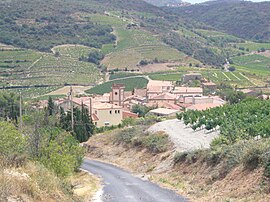 Looking down the road into Planèzes | |
 Coat of arms | |
show Location of Planèzes | |
 Planèzes | |
| Coordinates: 42°46′02″N 2°37′11″E / 42.7672°N 2.6197°ECoordinates: 42°46′02″N 2°37′11″E / 42.7672°N 2.6197°E | |
| Country | France |
| Region | Occitanie |
| Department | Pyrénées-Orientales |
| Arrondissement | Prades |
| Canton | La Vallée de l'Agly |
| Intercommunality | Agly Fenouillèdes |
| Government | |
| • Mayor (2020–2026) | Sidney Huillet[1] |
| Area 1 | 6.16 km2 (2.38 sq mi) |
| Population (Jan. 2018)[2] | 96 |
| • Density | 16/km2 (40/sq mi) |
| Time zone | UTC+01:00 (CET) |
| • Summer (DST) | UTC+02:00 (CEST) |
| INSEE/Postal code | 66143 /66720 |
| Elevation | 97–423 m (318–1,388 ft) (avg. 160 m or 520 ft) |
| 1 French Land Register data, which excludes lakes, ponds, glaciers > 1 km2 (0.386 sq mi or 247 acres) and river estuaries. | |


Planèzes (Catalan: Planeses) is a commune in the Pyrénées-Orientales department in southern France.
Geography[]
Planèzes is located in the canton of La Vallée de l'Agly and in the arrondissement of Perpignan. Planèzes is part of the Fenouillèdes.

Map of Planèzes and its surrounding communes
Toponymy[]
In occitan, the name of the commune is Planeses.
Population[]
| Year | Pop. | ±% p.a. |
|---|---|---|
| 1968 | 116 | — |
| 1975 | 82 | −4.83% |
| 1982 | 77 | −0.89% |
| 1990 | 80 | +0.48% |
| 1999 | 99 | +2.40% |
| 2007 | 96 | −0.38% |
| 2012 | 106 | +2.00% |
| 2017 | 99 | −1.36% |
| Source: INSEE[3] | ||
See also[]
External links[]
References[]
- ^ "Répertoire national des élus: les maires". data.gouv.fr, Plateforme ouverte des données publiques françaises (in French). 2 December 2020.
- ^ "Populations légales 2018". INSEE. 28 December 2020.
- ^ Population en historique depuis 1968, INSEE
| Wikimedia Commons has media related to Planèzes. |
This Pyrénées-Orientales geographical article is a stub. You can help Wikipedia by . |
Categories:
- Communes of Pyrénées-Orientales
- Fenouillèdes
- Pyrénées-Orientales geography stubs