La Combe-de-Lancey
La Combe-de-Lancey | |
|---|---|
 La Chapelle in La Combe-de-Lancey | |
show Location of La Combe-de-Lancey | |
 La Combe-de-Lancey | |
| Coordinates: 45°13′36″N 5°53′55″E / 45.2267°N 5.8986°ECoordinates: 45°13′36″N 5°53′55″E / 45.2267°N 5.8986°E | |
| Country | France |
| Region | Auvergne-Rhône-Alpes |
| Department | Isère |
| Arrondissement | Grenoble |
| Canton | Le Moyen Grésivaudan |
| Intercommunality | CC Le Grésivaudan |
| Government | |
| • Mayor (2020–2026) | Régine Villarino[1] |
| Area 1 | 19 km2 (7 sq mi) |
| Population (Jan. 2018)[2] | 705 |
| • Density | 37/km2 (96/sq mi) |
| Time zone | UTC+01:00 (CET) |
| • Summer (DST) | UTC+02:00 (CEST) |
| INSEE/Postal code | 38120 /38190 |
| Elevation | 316–2,813 m (1,037–9,229 ft) |
| 1 French Land Register data, which excludes lakes, ponds, glaciers > 1 km2 (0.386 sq mi or 247 acres) and river estuaries. | |


show This article may be expanded with text translated from the corresponding article in French. (December 2009) Click [show] for important translation instructions. |
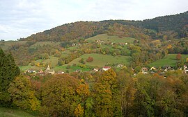
La Combe-de-Lancey (French pronunciation: [la kɔ̃b də lɑ̃sɛ]) is a commune in the Isère department in Auvergne-Rhône-Alpes region in southeastern France. The municipality covers an area of over 1,800 hectares. Located in the heart of the Belledonne, the town is bordered by Revel, Saint-Jean-le-Vieux, and Saint-Mury-Monteymond.
Population[]
|
|
See also[]
References[]
- ^ "Répertoire national des élus: les maires". data.gouv.fr, Plateforme ouverte des données publiques françaises (in French). 2 December 2020.
- ^ "Populations légales 2018". INSEE. 28 December 2020.
| Wikimedia Commons has media related to La Combe-de-Lancey. |
| show Authority control |
|---|
This Isère geographical article is a stub. You can help Wikipedia by . |
Categories:
- Communes of Isère
- Isère geography stubs