Lampaul-Ploudalmézeau
Lampaul-Ploudalmézeau
Lambaol-Gwitalmeze | |
|---|---|
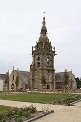 The parish church of Saint-Pol-Aurélien | |
show Location of Lampaul-Ploudalmézeau | |
 Lampaul-Ploudalmézeau | |
| Coordinates: 48°33′40″N 4°39′14″W / 48.5611°N 4.6539°WCoordinates: 48°33′40″N 4°39′14″W / 48.5611°N 4.6539°W | |
| Country | France |
| Region | Brittany |
| Department | Finistère |
| Arrondissement | Brest |
| Canton | Plabennec |
| Intercommunality | Pays d'Iroise |
| Government | |
| • Mayor (2020–2026) | Anne Apprioual[1] |
| Area 1 | 6.35 km2 (2.45 sq mi) |
| Population (Jan. 2018)[2] | 830 |
| • Density | 130/km2 (340/sq mi) |
| Time zone | UTC+01:00 (CET) |
| • Summer (DST) | UTC+02:00 (CEST) |
| INSEE/Postal code | 29099 /29830 |
| Elevation | 0–63 m (0–207 ft) |
| 1 French Land Register data, which excludes lakes, ponds, glaciers > 1 km2 (0.386 sq mi or 247 acres) and river estuaries. | |


Lampaul-Ploudalmézeau (Breton: Lambaol-Gwitalmeze) is a commune in the Finistère department of Brittany in north-western France.
Population[]
Inhabitants of Lampaul-Ploudalmézeau are called in French Lampaulais.
| Year | Pop. | ±% |
|---|---|---|
| 1962 | 594 | — |
| 1968 | 516 | −13.1% |
| 1975 | 538 | +4.3% |
| 1982 | 548 | +1.9% |
| 1990 | 595 | +8.6% |
| 1999 | 606 | +1.8% |
| 2008 | 727 | +20.0% |
| 2013 | 810 | +11.4% |
See also[]
References[]
- ^ "Répertoire national des élus: les maires". data.gouv.fr, Plateforme ouverte des données publiques françaises (in French). 2 December 2020.
- ^ "Populations légales 2018". INSEE. 28 December 2020.
External links[]
| Wikimedia Commons has media related to Lampaul-Ploudalmézeau. |
- Base Mérimée: Search for heritage in the commune, Ministère français de la Culture. (in French)
- Sports and leisure associations portal of Lampaul Ploudalmézeau
- Mayors of Finistère Association (in French)
This Finistère geographical article is a stub. You can help Wikipedia by . |
Categories:
- Communes of Finistère
- Finistère geography stubs