Le Folgoët
Le Folgoët
Ar Folgoad | |
|---|---|
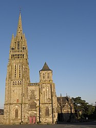 The basilica of Notre-Dame du Folgoët | |
 Coat of arms | |
show Location of Le Folgoët | |
 Le Folgoët | |
| Coordinates: 48°33′45″N 4°20′03″W / 48.5625°N 4.3342°WCoordinates: 48°33′45″N 4°20′03″W / 48.5625°N 4.3342°W | |
| Country | France |
| Region | Brittany |
| Department | Finistère |
| Arrondissement | Brest |
| Canton | Lesneven |
| Intercommunality | Lesneven Côte des Légendes |
| Government | |
| • Mayor (2014–2020) | Bernard Tanguy |
| Area 1 | 9.77 km2 (3.77 sq mi) |
| Population (Jan. 2018)[1] | 3,211 |
| • Density | 330/km2 (850/sq mi) |
| Time zone | UTC+01:00 (CET) |
| • Summer (DST) | UTC+02:00 (CEST) |
| INSEE/Postal code | 29055 /29260 |
| Elevation | 33–77 m (108–253 ft) |
| 1 French Land Register data, which excludes lakes, ponds, glaciers > 1 km2 (0.386 sq mi or 247 acres) and river estuaries. | |


Le Folgoët (Breton: Ar Folgoad) is a commune in the Finistère department and administrative region of Brittany in north-western France.
Population[]
In French the inhabitants of Le Folgoët are known as Folgoëtiens.
See also[]
- Communes of the Finistère department
- List of the works of Bastien and Henry Prigent
- List of works of the two Folgoët ateliers
- List of the works of the Maître de Plougastel
References[]
- ^ "Populations légales 2018". INSEE. 28 December 2020.
External links[]
- Official website (in French)
- Base Mérimée: Search for heritage in the commune, Ministère français de la Culture. (in French)
- Mayors of Finistère Association (in French)
| Wikimedia Commons has media related to Le Folgoët. |
| show Authority control |
|---|
This Finistère geographical article is a stub. You can help Wikipedia by . |
Categories:
- Communes of Finistère
- Finistère geography stubs