Plouyé
Plouyé
Plouie | |
|---|---|
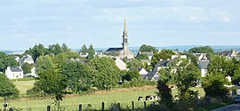 A general view of Plouyé | |
show Location of Plouyé | |
 Plouyé | |
| Coordinates: 48°18′58″N 3°44′11″W / 48.3161°N 3.7364°WCoordinates: 48°18′58″N 3°44′11″W / 48.3161°N 3.7364°W | |
| Country | France |
| Region | Brittany |
| Department | Finistère |
| Arrondissement | Châteaulin |
| Canton | Carhaix-Plouguer |
| Intercommunality | Monts d'Arrée Communauté |
| Government | |
| • Mayor (2020–2026) | Grégory Le Guillou |
| Area 1 | 37.55 km2 (14.50 sq mi) |
| Population (Jan. 2018)[1] | 662 |
| • Density | 18/km2 (46/sq mi) |
| Time zone | UTC+01:00 (CET) |
| • Summer (DST) | UTC+02:00 (CEST) |
| INSEE/Postal code | 29211 /29690 |
| Elevation | 67–246 m (220–807 ft) |
| 1 French Land Register data, which excludes lakes, ponds, glaciers > 1 km2 (0.386 sq mi or 247 acres) and river estuaries. | |


Plouyé (French pronunciation: [pluje]; Breton: Plouie "Parish of Ia"[2]) is a commune in the Finistère department of Brittany in northwestern France.
Population[]
Inhabitants of Plouyé are called in French Plouyéziens.
|
| ||||||||||||||||||||||||||||||||||||||||||||||||||||||||||||||||||||||||||||||||||||||||||||||||||||||||||||||||||
| Source: EHESS[3] and INSEE (1968-2017)[4] | |||||||||||||||||||||||||||||||||||||||||||||||||||||||||||||||||||||||||||||||||||||||||||||||||||||||||||||||||||
See also[]
References[]
- ^ "Populations légales 2018". INSEE. 28 December 2020.
- ^ Doble, Gilbert Hunter (1960). The Saints of Cornwall.
- ^ Des villages de Cassini aux communes d'aujourd'hui: Commune data sheet Plouyé, EHESS. (in French)
- ^ Population en historique depuis 1968, INSEE
- Mayors of Finistère Association (in French)
External links[]
| Wikimedia Commons has media related to Plouyé. |
- Official website (in French)
This Finistère geographical article is a stub. You can help Wikipedia by . |
Categories:
- Communes of Finistère
- Finistère geography stubs