Plougourvest
Plougourvest
Gwikourvest | |
|---|---|
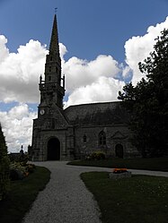 The parish church of Saint-Pierre | |
 Coat of arms | |
show Location of Plougourvest | |
 Plougourvest | |
| Coordinates: 48°33′20″N 4°05′04″W / 48.5556°N 4.0844°WCoordinates: 48°33′20″N 4°05′04″W / 48.5556°N 4.0844°W | |
| Country | France |
| Region | Brittany |
| Department | Finistère |
| Arrondissement | Morlaix |
| Canton | Landivisiau |
| Intercommunality | Pays de Landivisiau |
| Government | |
| • Mayor (2020–2026) | Jean Jézéquel[1] |
| Area 1 | 14.07 km2 (5.43 sq mi) |
| Population (Jan. 2018)[2] | 1,413 |
| • Density | 100/km2 (260/sq mi) |
| Time zone | UTC+01:00 (CET) |
| • Summer (DST) | UTC+02:00 (CEST) |
| INSEE/Postal code | 29193 /29400 |
| Elevation | 62–126 m (203–413 ft) |
| 1 French Land Register data, which excludes lakes, ponds, glaciers > 1 km2 (0.386 sq mi or 247 acres) and river estuaries. | |


Plougourvest (Breton: Gwikourvest) is a commune in the Finistère department of Brittany in north-western France.
See also[]
- Communes of the Finistère department
- Yann Larhantec Sculptor with work in Plougourvest cemetery
References[]
- ^ "Répertoire national des élus: les maires". data.gouv.fr, Plateforme ouverte des données publiques françaises (in French). 2 December 2020.
- ^ "Populations légales 2018". INSEE. 28 December 2020.
External links[]
| Wikimedia Commons has media related to Plougourvest. |
- Base Mérimée: Search for heritage in the commune, Ministère français de la Culture. (in French)
- Mayors of Finistère Association (in French)
This Finistère geographical article is a stub. You can help Wikipedia by . |
Categories:
- Communes of Finistère
- Finistère geography stubs