Leuhan
Leuhan
Leuc'han | |
|---|---|
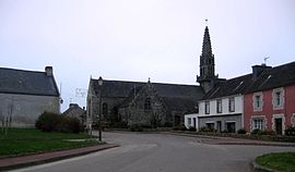 The parish church of Saint-Théleau and surrounding buildings | |
show Location of Leuhan | |
 Leuhan | |
| Coordinates: 48°06′00″N 3°46′59″W / 48.1000°N 3.7831°WCoordinates: 48°06′00″N 3°46′59″W / 48.1000°N 3.7831°W | |
| Country | France |
| Region | Brittany |
| Department | Finistère |
| Arrondissement | Châteaulin |
| Canton | Briec |
| Intercommunality | Haute Cornouaille |
| Government | |
| • Mayor (2014–2020) | André Loussouarn |
| Area 1 | 32.75 km2 (12.64 sq mi) |
| Population (Jan. 2018)[1] | 830 |
| • Density | 25/km2 (66/sq mi) |
| Time zone | UTC+01:00 (CET) |
| • Summer (DST) | UTC+02:00 (CEST) |
| INSEE/Postal code | 29125 /29390 |
| Elevation | 97–246 m (318–807 ft) |
| 1 French Land Register data, which excludes lakes, ponds, glaciers > 1 km2 (0.386 sq mi or 247 acres) and river estuaries. | |


Leuhan (Leuc'han in Breton) is a commune in the Finistère department of Brittany in north-western France.
Population[]
Inhabitants of Leuhan are called in French Leuhannais.
|
| ||||||||||||||||||||||||||||||||||||||||||||||||||||||||||||||||||||||||||||||||||||||||||||||||||||||||||||||||||
| Source: EHESS[2] and INSEE (1968-2017)[3] | |||||||||||||||||||||||||||||||||||||||||||||||||||||||||||||||||||||||||||||||||||||||||||||||||||||||||||||||||||
See also[]
References[]
- ^ "Populations légales 2018". INSEE. 28 December 2020.
- ^ Des villages de Cassini aux communes d'aujourd'hui: Commune data sheet Leuhan, EHESS. (in French)
- ^ Population en historique depuis 1968, INSEE
External links[]
| Wikimedia Commons has media related to Leuhan. |
- Official website (in French)
- Base Mérimée: Search for heritage in the commune, Ministère français de la Culture. (in French)
- Mayors of Finistère Association (in French)
This Finistère geographical article is a stub. You can help Wikipedia by . |
Categories:
- Communes of Finistère
- Finistère geography stubs