Locunolé
Locunolé
Lokunole | |
|---|---|
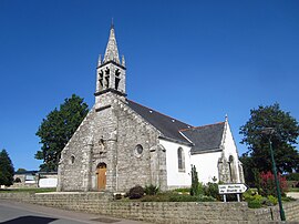 The church of Saint-Guénolé | |
show Location of Locunolé | |
 Locunolé | |
| Coordinates: 47°56′13″N 3°28′38″W / 47.9369°N 3.4772°WCoordinates: 47°56′13″N 3°28′38″W / 47.9369°N 3.4772°W | |
| Country | France |
| Region | Brittany |
| Department | Finistère |
| Arrondissement | Quimper |
| Canton | Quimperlé |
| Intercommunality | Quimperlé Communauté |
| Government | |
| • Mayor (2014–2020) | Murielle Le Rest |
| Area 1 | 16.78 km2 (6.48 sq mi) |
| Population (Jan. 2018)[1] | 1,156 |
| • Density | 69/km2 (180/sq mi) |
| Time zone | UTC+01:00 (CET) |
| • Summer (DST) | UTC+02:00 (CEST) |
| INSEE/Postal code | 29136 /29310 |
| Elevation | 12–121 m (39–397 ft) |
| 1 French Land Register data, which excludes lakes, ponds, glaciers > 1 km2 (0.386 sq mi or 247 acres) and river estuaries. | |


Locunolé (Breton: Lokunole) is a commune in the Finistère department of Brittany in north-western France.
Population[]
Inhabitants of Locunolé are called in French Locunolois.
|
| |||||||||||||||||||||||||||||||||||||||||||||||||||||||||||||||||||||||||||||||||||||||||||||||||||||||||||||||
| Source: EHESS[2] and INSEE (1968-2017)[3] | ||||||||||||||||||||||||||||||||||||||||||||||||||||||||||||||||||||||||||||||||||||||||||||||||||||||||||||||||
See also[]
- Communes of the Finistère department
- Entry on sculptor of local war memorial Jean Joncourt
References[]
- ^ "Populations légales 2018". INSEE. 28 December 2020.
- ^ Des villages de Cassini aux communes d'aujourd'hui: Commune data sheet Locunolé, EHESS. (in French)
- ^ Population en historique depuis 1968, INSEE
External links[]
| Wikimedia Commons has media related to Locunolé. |
- Mayors of Finistère Association (in French)
This Finistère geographical article is a stub. You can help Wikipedia by . |
Categories:
- Communes of Finistère
- Finistère geography stubs