Pont-Croix
Pont-Croix
Pontekroaz | |
|---|---|
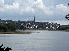 A general view of Pont-Croix | |
 Coat of arms | |
show Location of Pont-Croix | |
 Pont-Croix | |
| Coordinates: 48°02′35″N 4°29′17″W / 48.043°N 4.488°WCoordinates: 48°02′35″N 4°29′17″W / 48.043°N 4.488°W | |
| Country | France |
| Region | Brittany |
| Department | Finistère |
| Arrondissement | Quimper |
| Canton | Douarnenez |
| Intercommunality | Cap Sizun - Pointe du Raz |
| Government | |
| • Mayor (2020–2026) | Benoît Lauriou[1] |
| Area 1 | 8.09 km2 (3.12 sq mi) |
| Population (Jan. 2018)[2] | 1,570 |
| • Density | 190/km2 (500/sq mi) |
| Time zone | UTC+01:00 (CET) |
| • Summer (DST) | UTC+02:00 (CEST) |
| INSEE/Postal code | 29218 /29790 |
| Elevation | 2–73 m (6.6–239.5 ft) |
| 1 French Land Register data, which excludes lakes, ponds, glaciers > 1 km2 (0.386 sq mi or 247 acres) and river estuaries. | |


Pont-Croix (Breton: Pontekroaz) is a commune in the Finistère department of Brittany in north-western France.
The town lies about 5 km (3.1 mi) from Audierne on the road to Douarnenez and is connected to Plouhinec by a small, scenic road that passes through the valley.
International relations[]
It is twinned with the civil Parish of Constantine in Kerrier, Cornwall.[3]
Population[]
Inhabitants of Pont-Croix are called in French Pontécruciens.
Sights[]
From Pont-Croix, short trips can be made to Pointe du Raz, Pointe du Van, and Baie des Trépassés. On the road to Audierne, one can enjoy a marvelous view of the Goyen river valley.
The Monastery Church of Notre-Dame de Roscudon, which dates from the early 13th century, has a 67 m high spire that served as the model for the spires of Quimper Cathedral.
Pont-Croix's cobbled streets (Ruelles pavées) and medieval houses are located around a market and a church. The market is held every Thursday morning.[4]
Other points of interest are:
- The Bridge over the River Goyen
- The Chapel of Saint Vincent
Notable people[]
See also[]
References[]
- ^ "Répertoire national des élus: les maires". data.gouv.fr, Plateforme ouverte des données publiques françaises (in French). 2 December 2020.
- ^ "Populations légales 2018". INSEE. 28 December 2020.
- ^ "Constantine Twinning Association webpage". constantinecornwall.com. Retrieved 15 April 2018.
- ^ "- ouest-cornouaille2". www.ouest-cornouaille.com. Retrieved 15 April 2018.
- The information in this article is based on a translation of its German equivalent.
External links[]
| Wikimedia Commons has media related to Pont-Croix. |
- Base Mérimée: Search for heritage in the commune, Ministère français de la Culture. (in French)
- Mayors of Finistère Association (in French)
| show Authority control |
|---|
This Finistère geographical article is a stub. You can help Wikipedia by . |
- Communes of Finistère
- Finistère geography stubs