Saint-Sauveur, Isère
show This article may be expanded with text translated from the corresponding article in French. (December 2009) Click [show] for important translation instructions. |
Saint-Sauveur | |
|---|---|
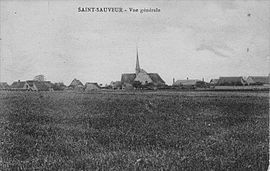 Saint-Sauveur in 1921 | |
show Location of Saint-Sauveur | |
 Saint-Sauveur | |
| Coordinates: 45°09′12″N 5°20′32″E / 45.1533°N 5.3422°ECoordinates: 45°09′12″N 5°20′32″E / 45.1533°N 5.3422°E | |
| Country | France |
| Region | Auvergne-Rhône-Alpes |
| Department | Isère |
| Arrondissement | Grenoble |
| Canton | Le Sud Grésivaudan |
| Intercommunality | Saint-Marcellin Vercors Isère |
| Government | |
| • Mayor (2020–2026) | Marie-Jeanne Dabadie |
| Area 1 | 9.42 km2 (3.64 sq mi) |
| Population (Jan. 2018)[1] | 2,102 |
| • Density | 220/km2 (580/sq mi) |
| Time zone | UTC+01:00 (CET) |
| • Summer (DST) | UTC+02:00 (CEST) |
| INSEE/Postal code | 38454 /38160 |
| Elevation | 160–301 m (525–988 ft) (avg. 276 m or 906 ft) |
| 1 French Land Register data, which excludes lakes, ponds, glaciers > 1 km2 (0.386 sq mi or 247 acres) and river estuaries. | |


Saint-Sauveur (French pronunciation: [sɛ̃ sovœʁ] (![]() listen)) is a commune in the Isère department in southeastern France.
listen)) is a commune in the Isère department in southeastern France.
Population[]
|
|
Transport[]
There is a train station in the nearby town of Saint Marcellin
See also[]
References[]
| Wikimedia Commons has media related to Saint-Sauveur (Isère). |
- ^ "Populations légales 2018". INSEE. 28 December 2020.
This Isère geographical article is a stub. You can help Wikipedia by . |
Categories:
- Communes of Isère
- Isère geography stubs