Voreppe
show This article may be expanded with text translated from the corresponding article in French. (December 2009) Click [show] for important translation instructions. |
Voreppe | |
|---|---|
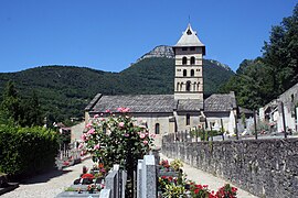 Church of Saint-Didier | |
 Coat of arms | |
show Location of Voreppe | |
 Voreppe | |
| Coordinates: 45°17′55″N 5°38′15″E / 45.2986°N 5.6375°ECoordinates: 45°17′55″N 5°38′15″E / 45.2986°N 5.6375°E | |
| Country | France |
| Region | Auvergne-Rhône-Alpes |
| Department | Isère |
| Arrondissement | Grenoble |
| Canton | Voiron |
| Intercommunality | Pays Voironnais |
| Government | |
| • Mayor (2020–2026) | Luc Rémond[1] |
| Area 1 | 28.65 km2 (11.06 sq mi) |
| Population (Jan. 2018)[2] | 9,229 |
| • Density | 320/km2 (830/sq mi) |
| Time zone | UTC+01:00 (CET) |
| • Summer (DST) | UTC+02:00 (CEST) |
| INSEE/Postal code | 38565 /38340 |
| Elevation | 185–1,702 m (607–5,584 ft) (avg. 249 m or 817 ft) |
| 1 French Land Register data, which excludes lakes, ponds, glaciers > 1 km2 (0.386 sq mi or 247 acres) and river estuaries. | |


Voreppe is a commune in the Isère department in southeastern France. The commune contains the Monastère de Chalais, a Dominican monastery about 7 kilometres (4.3 mi) from the town of Voreppe.
Population[]
|
|
Twin towns[]
Voreppe is twinned with:
 Lichtenstein, Baden-Württemberg, Germany, since 1992
 Castelnovo ne' Monti, Italy, since 1994
 Lapoș, Romania, since 1990
See also[]
- Urban unit of Grenoble
- Communes of the Isère department
References[]
- ^ "Répertoire national des élus: les maires". data.gouv.fr, Plateforme ouverte des données publiques françaises (in French). 2 December 2020.
- ^ "Populations légales 2018". INSEE. 28 December 2020.
| Wikimedia Commons has media related to Voreppe. |
| show Authority control |
|---|
This Isère geographical article is a stub. You can help Wikipedia by . |
Categories:
- Communes of Isère
- Isère geography stubs