Bourg-Blanc
Bourg-Blanc
Ar Vourc'h-Wenn | |
|---|---|
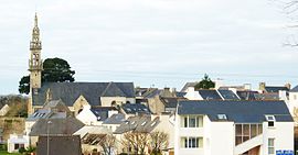 A general view of Bourg-Blanc | |
 Coat of arms | |
show Location of Bourg-Blanc | |
 Bourg-Blanc | |
| Coordinates: 48°30′01″N 4°30′13″W / 48.5003°N 4.5036°WCoordinates: 48°30′01″N 4°30′13″W / 48.5003°N 4.5036°W | |
| Country | France |
| Region | Brittany |
| Department | Finistère |
| Arrondissement | Brest |
| Canton | Plabennec |
| Government | |
| • Mayor (2020–2026) | Bernard Gibergues[1] |
| Area 1 | 28.31 km2 (10.93 sq mi) |
| Population (Jan. 2018)[2] | 3,560 |
| • Density | 130/km2 (330/sq mi) |
| Time zone | UTC+01:00 (CET) |
| • Summer (DST) | UTC+02:00 (CEST) |
| INSEE/Postal code | 29015 /29860 |
| Elevation | 25–98 m (82–322 ft) |
| 1 French Land Register data, which excludes lakes, ponds, glaciers > 1 km2 (0.386 sq mi or 247 acres) and river estuaries. | |


Bourg-Blanc (Breton: Ar Vourc'h-Wenn) is a commune in the Finistère department of Brittany in north-western France.
Population[]
Inhabitants of Bourg-Blanc are called Blanc-Bourgeois in French.
|
|
See also[]
References[]
- ^ "Répertoire national des élus: les maires". data.gouv.fr, Plateforme ouverte des données publiques françaises (in French). 2 December 2020.
- ^ "Populations légales 2018". INSEE. 28 December 2020.
External links[]
| Wikimedia Commons has media related to Bourg-Blanc. |
- Official website (in French)
- Base Mérimée: Search for heritage in the commune, Ministère français de la Culture. (in French)
- Mayors of Finistère Association Archived 2021-03-18 at the Wayback Machine (in French)
| show Authority control |
|---|
This Finistère geographical article is a stub. You can help Wikipedia by . |
Categories:
- Communes of Finistère
- Finistère geography stubs