Châteaubourg, Ille-et-Vilaine
Châteaubourg
Kastell-Bourc'h | |
|---|---|
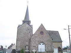
 Saint-Pierre church | |
 Coat of arms | |
show Location of Châteaubourg | |
 Châteaubourg | |
| Coordinates: 48°06′43″N 1°24′07″W / 48.1119°N 1.4019°WCoordinates: 48°06′43″N 1°24′07″W / 48.1119°N 1.4019°W | |
| Country | France |
| Region | Brittany |
| Department | Ille-et-Vilaine |
| Arrondissement | Fougères-Vitré |
| Canton | Châteaugiron |
| Intercommunality | CA Vitré Communauté |
| Government | |
| • Mayor (2020–2026) | Teddy Régnier[1] |
| Area 1 | 28.60 km2 (11.04 sq mi) |
| Population (Jan. 2018)[2] | 7,240 |
| • Density | 250/km2 (660/sq mi) |
| Time zone | UTC+01:00 (CET) |
| • Summer (DST) | UTC+02:00 (CEST) |
| INSEE/Postal code | 35068 /35220 |
| Elevation | 35–117 m (115–384 ft) |
| 1 French Land Register data, which excludes lakes, ponds, glaciers > 1 km2 (0.386 sq mi or 247 acres) and river estuaries. | |


Châteaubourg (Breton: Kastell-Bourc'h, Gallo: Chastèu-Bórg) is a commune in the Ille-et-Vilaine department in Brittany in northwestern France.
Population[]
Inhabitants of Châteaubourg are called Castelbourgeois in French.
| Year | Pop. | ±% |
|---|---|---|
| 1962 | 2,352 | — |
| 1968 | 2,634 | +12.0% |
| 1975 | 2,937 | +11.5% |
| 1982 | 3,526 | +20.1% |
| 1990 | 4,056 | +15.0% |
| 1999 | 4,877 | +20.2% |
| 2008 | 6,450 | +32.3% |
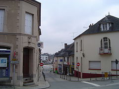
Châteaubourg Inner town

Saint-Melaine calvary

Saint-Pierre church

«Ar Milin» stepping over the Vilaine
Saint-Melaine church

Old town house


See also[]
- Communes of the Ille-et-Vilaine department
References[]
- ^ "Répertoire national des élus: les maires". data.gouv.fr, Plateforme ouverte des données publiques françaises (in French). 2 December 2020.
- ^ "Populations légales 2018". INSEE. 28 December 2020.
External links[]
| Wikimedia Commons has media related to Châteaubourg (Ille-et-Vilaine). |
- Base Mérimée: Search for heritage in the commune, Ministère français de la Culture. (in French)
- Mayors of Ille-et-Vilaine Association (in French)
| show Communes of the Ille-et-Vilaine department |
|---|
This Ille-et-Vilaine geographical article is a stub. You can help Wikipedia by . |
Categories:
- Communes of Ille-et-Vilaine
- Ille-et-Vilaine geography stubs