La Selle-en-Luitré
La Selle-en-Luitré
Kell-Loezherieg | |
|---|---|
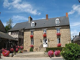 Town hall | |
 Coat of arms | |
show Location of La Selle-en-Luitré | |
 La Selle-en-Luitré | |
| Coordinates: 48°18′41″N 1°07′36″W / 48.3114°N 1.1267°WCoordinates: 48°18′41″N 1°07′36″W / 48.3114°N 1.1267°W | |
| Country | France |
| Region | Brittany |
| Department | Ille-et-Vilaine |
| Arrondissement | Fougères-Vitré |
| Canton | Fougères-2 |
| Intercommunality | Fougères |
| Government | |
| • Mayor (2014–2020) | Jean-Pierre Deshayes |
| Area 1 | 7.32 km2 (2.83 sq mi) |
| Population (Jan. 2018)[1] | 615 |
| • Density | 84/km2 (220/sq mi) |
| Time zone | UTC+01:00 (CET) |
| • Summer (DST) | UTC+02:00 (CEST) |
| INSEE/Postal code | 35324 /35133 |
| Elevation | 70–122 m (230–400 ft) |
| 1 French Land Register data, which excludes lakes, ponds, glaciers > 1 km2 (0.386 sq mi or 247 acres) and river estuaries. | |


La Selle-en-Luitré (Breton: Kell-Loezherieg) is a commune in the Ille-et-Vilaine department in Brittany in northwestern France.
Population[]
Inhabitants of La Selle-en-Luitré are called Sellois in French.
| Year | Pop. | ±% |
|---|---|---|
| 1962 | 340 | — |
| 1968 | 350 | +2.9% |
| 1975 | 323 | −7.7% |
| 1982 | 347 | +7.4% |
| 1990 | 385 | +11.0% |
| 1999 | 425 | +10.4% |
| 2009 | 542 | +27.5% |
See also[]
- Communes of the Ille-et-Vilaine department
References[]
- ^ "Populations légales 2018". INSEE. 28 December 2020.
External links[]
| Wikimedia Commons has media related to La Selle-en-Luitré. |
- Base Mérimée: Search for heritage in the commune, Ministère français de la Culture. (in French)
- Mayors of Ille-et-Vilaine Association (in French)
| show Communes of the Ille-et-Vilaine department |
|---|
This Ille-et-Vilaine geographical article is a stub. You can help Wikipedia by . |
Categories:
- Communes of Ille-et-Vilaine
- Ille-et-Vilaine geography stubs