Moutiers, Ille-et-Vilaine
Moutiers
Mousterioù | |
|---|---|
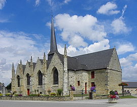 The church of Saint-Martin | |
show Location of Moutiers | |
 Moutiers | |
| Coordinates: 47°58′05″N 1°12′45″W / 47.9681°N 1.2125°WCoordinates: 47°58′05″N 1°12′45″W / 47.9681°N 1.2125°W | |
| Country | France |
| Region | Brittany |
| Department | Ille-et-Vilaine |
| Arrondissement | Fougères-Vitré |
| Canton | La Guerche-de-Bretagne |
| Intercommunality | CA Vitré Communauté |
| Government | |
| • Mayor (2020–2026) | Yves Colas[1] |
| Area 1 | 17.64 km2 (6.81 sq mi) |
| Population (Jan. 2018)[2] | 927 |
| • Density | 53/km2 (140/sq mi) |
| Time zone | UTC+01:00 (CET) |
| • Summer (DST) | UTC+02:00 (CEST) |
| INSEE/Postal code | 35200 /35130 |
| Elevation | 51–108 m (167–354 ft) |
| 1 French Land Register data, which excludes lakes, ponds, glaciers > 1 km2 (0.386 sq mi or 247 acres) and river estuaries. | |


Moutiers (French pronunciation: [mutje]; Breton: Mousterioù; Gallo: Móstiers) is a commune in the Ille-et-Vilaine department of Brittany in northwestern France.
Population[]
Inhabitants of Moutiers are called in French moutierrains.
| Year | Pop. | ±% |
|---|---|---|
| 1962 | 583 | — |
| 1968 | 650 | +11.5% |
| 1975 | 594 | −8.6% |
| 1982 | 625 | +5.2% |
| 1990 | 638 | +2.1% |
| 1999 | 655 | +2.7% |
| 2008 | 871 | +33.0% |
See also[]
- Communes of the Ille-et-Vilaine department
References[]
- ^ "Répertoire national des élus: les maires". data.gouv.fr, Plateforme ouverte des données publiques françaises (in French). 2 December 2020.
- ^ "Populations légales 2018". INSEE. 28 December 2020.
External links[]
| Wikimedia Commons has media related to Moutiers (Ille-et-Vilaine). |
- Base Mérimée: Search for heritage in the commune, Ministère français de la Culture. (in French)
- Mayors of Ille-et-Vilaine Association (in French)
| show Communes of the Ille-et-Vilaine department |
|---|
This Ille-et-Vilaine geographical article is a stub. You can help Wikipedia by . |
Categories:
- Communes of Ille-et-Vilaine
- Ille-et-Vilaine geography stubs